IMAGES TAKEN NEAR TO
Llanfwrog, RUTHIN, LL15 2AL
Introduction
This page details the photographs taken nearby to LL15 2AL by members of the Geograph project.
The Geograph project started in 2005 with the aim of publishing, organising and preserving representative images for every square kilometre of Great Britain, Ireland and the Isle of Man.

There are currently over 7.5m images from over14,400 individuals and you can help contribute to the project by visiting https://www.geograph.org.uk
Image Map (Loading...)


Getting Data...Please wait
Leaflet Map data © OpenStreetMap
Images are licensed for reuse under creativecommons.org/licenses/by-sa/2.0
Notes
- Clicking on the map will re-center to the selected point.
- The higher the marker number, the further away the image location is from the centre of the postcode.
Image Listing (5 Images Found)
Images are licensed for reuse under creativecommons.org/licenses/by-sa/2.0
Image
Details
Distance
1
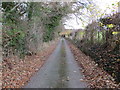
Hedge and tree-lined minor road near Y Bwthyn and Penrhengoed
Looking northward.
Image: © Peter Wood
Taken: 19 Nov 2018
0.12 miles
2
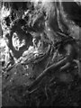
Gwreiddiau derw a ffawydd wedi'u plethu / Oak and beech roots intertwined
This wooded country lane has a Narnian feel!
Image: © Ceri Thomas
Taken: 27 Sep 2012
0.14 miles
3
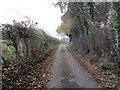
Hedge and tree-lined minor road near Y Bwthyn and Penrhengoed
Looking south-eastward.
Image: © Peter Wood
Taken: 19 Nov 2018
0.16 miles
5
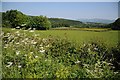
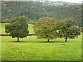
The Clwyd valley
Farmland in the Clwyd valley, the river flows through the valley below the wooded hillside.
Image: © Philip Halling
Taken: 11 Jun 2015
0.22 miles