IMAGES TAKEN NEAR TO
Llanbedr Dyffryn Clwyd, RUTHIN, LL15 1YE
Introduction
This page details the photographs taken nearby to LL15 1YE by members of the Geograph project.
The Geograph project started in 2005 with the aim of publishing, organising and preserving representative images for every square kilometre of Great Britain, Ireland and the Isle of Man.

There are currently over 7.5m images from over14,400 individuals and you can help contribute to the project by visiting https://www.geograph.org.uk
Image Map
Images are licensed for reuse under creativecommons.org/licenses/by-sa/2.0
Notes
- Clicking on the map will re-center to the selected point.
- The higher the marker number, the further away the image location is from the centre of the postcode.
Image Listing (12 Images Found)
Images are licensed for reuse under creativecommons.org/licenses/by-sa/2.0
Image
Details
Distance
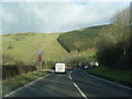
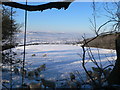
4
Lay-by on the A494 just below the Clwyd Gate hotel
Moel Eithinen is the hill in front.
Image: © Eirian Evans
Taken: 8 Jan 2010
0.09 miles
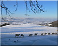
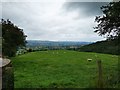
5
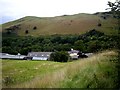
Sheep at Rhesgoed Farm, Llanbedr
With a good view of the Vale of Clwyd in the distance.
Image: © Eirian Evans
Taken: 8 Jan 2010
0.09 miles
6
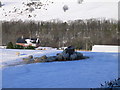
Winter feed for sheep at Rhesgoed, Llanbedr
Image: © Eirian Evans
Taken: 8 Jan 2010
0.09 miles
7
Sheep at Rhesgoed, Llanbedr
The Vale of Clwyd beyond.
Image: © Eirian Evans
Taken: 8 Jan 2010
0.09 miles
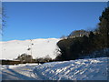
8
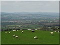
Sheep pasture at Rhesgoed
Looking west over the Vale of Clwyd
Image: © Neil Theasby
Taken: 7 Apr 2017
0.10 miles
9
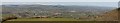
Vale of Clwyd
The Vale of Clwyd taken from Rhesgoed on the A494, showing the towns of Ruthin and Denbigh.
Image: © ErrolEdwards
Taken: 29 Mar 2009
0.10 miles
10
View West from the A494
Clwydian Range taken from a lay-by near Rhesgoed.
Image: © James Emmans
Taken: 21 Aug 2019
0.10 miles