IMAGES TAKEN NEAR TO
Llanbedr Dyffryn Clwyd, RUTHIN, LL15 1SP
Introduction
This page details the photographs taken nearby to LL15 1SP by members of the Geograph project.
The Geograph project started in 2005 with the aim of publishing, organising and preserving representative images for every square kilometre of Great Britain, Ireland and the Isle of Man.

There are currently over 7.5m images from over14,400 individuals and you can help contribute to the project by visiting https://www.geograph.org.uk
Image Map (Loading...)


Getting Data...Please wait
Leaflet Map data © OpenStreetMap
Images are licensed for reuse under creativecommons.org/licenses/by-sa/2.0
Notes
- Clicking on the map will re-center to the selected point.
- The higher the marker number, the further away the image location is from the centre of the postcode.
Image Listing (4 Images Found)
Images are licensed for reuse under creativecommons.org/licenses/by-sa/2.0
Image
Details
Distance
1
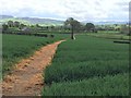
Well-defined footpath near Hirwaen
The footpath Image from the opposite direction
Image: © Eirian Evans
Taken: 30 Apr 2020
0.13 miles
2
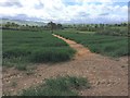
Well-defined footpath through a field near Hirwaen
Image: © Eirian Evans
Taken: 30 Apr 2020
0.13 miles
3
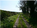
Track between the B5429 and Pentry Smithy
Image: © Eirian Evans
Taken: 19 Apr 2009
0.18 miles
4
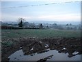
Farmland at Wern
Rough pasture land near Wern a few miles outside Llanbedr DC
Image: © Dot Potter
Taken: Unknown
0.20 miles