IMAGES TAKEN NEAR TO
Station Road, RUTHIN, LL15 1AT
Introduction
This page details the photographs taken nearby to Station Road, LL15 1AT by members of the Geograph project.
The Geograph project started in 2005 with the aim of publishing, organising and preserving representative images for every square kilometre of Great Britain, Ireland and the Isle of Man.

There are currently over 7.5m images from over14,400 individuals and you can help contribute to the project by visiting https://www.geograph.org.uk
Image Map (Loading...)


Getting Data...Please wait
Leaflet Map data © OpenStreetMap
Images are licensed for reuse under creativecommons.org/licenses/by-sa/2.0
Notes
- Clicking on the map will re-center to the selected point.
- The higher the marker number, the further away the image location is from the centre of the postcode.
Image Listing (422 Images Found)
Images are licensed for reuse under creativecommons.org/licenses/by-sa/2.0
Image
Details
Distance
1
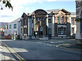
County Hall, Ruthin
This is the original building; a much larger modern range of offices now lies behind it.
Image: © Nigel Brown
Taken: 18 Oct 2004
0.00 miles
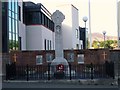
2
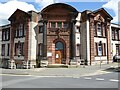
Council Offices Ruthin
The district councils office for Denbighshire County Council. A rather grand baroque style building designed by Walter D Wiles and built in 1907-08.
Image: © Philip Halling
Taken: 25 May 2021
0.01 miles
3
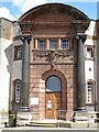
Detail of Council offices building
Detail of the district councils offices in Ruthun, a grand baroque style building designed by Walter D Wiles and built in 1907-08.
Image: © Philip Halling
Taken: 25 May 2021
0.01 miles
4
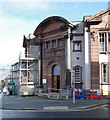
The County Offices at the junction of Market Street and Wynnstay Road, Ruthin
Image: © habiloid
Taken: 16 Feb 2024
0.01 miles
5
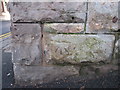
Bench mark on Ruthin Town Hall
This bench mark is on the north west face of the town hall at the corner of Stryt y Farchnad/Market Street and Ffordd Wynnstay.
Image: © John S Turner
Taken: 17 Jan 2010
0.02 miles
6
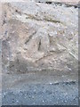
Ordnance Survey Cut Mark
This OS cut mark can be found on the north angle of the Town Hall. It marks a point 69.238m above mean sea level.
Image: © Adrian Dust
Taken: 8 Aug 2015
0.02 miles
8
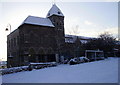
Ruthin in the snow - the Town Hall
Built in the 19th C - a previous town hall was sited on the town square. The Town Hall is on the corner of Wynnstay Road and Market Street.
Image: © Eirian Evans
Taken: 6 Jan 2010
0.02 miles
9
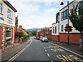
Ruthin - Market Street
View north with the Clwydian Range on the horizon.
Image: © James Emmans
Taken: 21 Aug 2019
0.02 miles
