IMAGES TAKEN NEAR TO
Tan Y Bryn, RUTHIN, LL15 1AQ
Introduction
This page details the photographs taken nearby to Tan Y Bryn, LL15 1AQ by members of the Geograph project.
The Geograph project started in 2005 with the aim of publishing, organising and preserving representative images for every square kilometre of Great Britain, Ireland and the Isle of Man.

There are currently over 7.5m images from over14,400 individuals and you can help contribute to the project by visiting https://www.geograph.org.uk
Image Map (Loading...)


Getting Data...Please wait
Leaflet Map data © OpenStreetMap
Images are licensed for reuse under creativecommons.org/licenses/by-sa/2.0
Notes
- Clicking on the map will re-center to the selected point.
- The higher the marker number, the further away the image location is from the centre of the postcode.
Image Listing (15 Images Found)
Images are licensed for reuse under creativecommons.org/licenses/by-sa/2.0
Image
Details
Distance
3
Vale of Clwyd
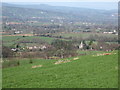
View from the bank above Llwynedd looking towards St Peters Church in Llanbedr Dyffryn Clwyd
Image: © Sian Williams
Taken: 8 Mar 2007
0.15 miles

5

Llanbedr Dyffryn Clwyd Parish church and graveyard
The parish church to the centre of the village seen through the bare winter trees in the graveyard
Image: © Dot Potter
Taken: Unknown
0.21 miles
6

Approach to Llanbedr DC
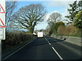
Coming into the village the parish church to the left and the village pub to the right
Image: © Dot Potter
Taken: Unknown
0.21 miles
8
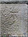
Bench mark on St Peter's church, Llanbedr-Dyffryn-Clwyd
This Ordnance Survey bench mark is on the east end of St Peter's church. The church was built in 1863 and the cut mark is recorded on the 1874 O.S.map. See also Image
Image: © John S Turner
Taken: 18 Sep 2018
0.23 miles
9
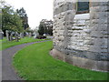
The east end of St Peter's church Llanbedr-Dyffryn-Clwyd
There is an Ordnance Survey bench mark on the east end of the church, low down to the right of the window - Image
Image: © John S Turner
Taken: 18 Sep 2018
0.23 miles
10
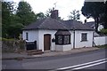
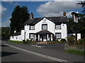
Former Tollhouse in Llanbedr Dyffryn Clwyd
Llanbedr Toll House by the A494, in parish of Llanbedr Dyffryn Clwyd (Denbighshire District), The Gate House, opposite the church in village centre, North East of junction with the B5429.
Grade II listed by Cadw.
Reference Number: 21928 https://cadwpublic-api.azurewebsites.net/reports/listedbuilding/FullReport?lang=&id=21928
To be surveyed
Milestone Society National ID: DEN.LDC
Image: © Milestone Society
Taken: Unknown
0.23 miles