IMAGES TAKEN NEAR TO
Spinney Walk, WREXHAM, LL14 6TE
Introduction
This page details the photographs taken nearby to Spinney Walk, LL14 6TE by members of the Geograph project.
The Geograph project started in 2005 with the aim of publishing, organising and preserving representative images for every square kilometre of Great Britain, Ireland and the Isle of Man.

There are currently over 7.5m images from over14,400 individuals and you can help contribute to the project by visiting https://www.geograph.org.uk
Image Map (Loading...)


Getting Data...Please wait
Leaflet Map data © OpenStreetMap
Images are licensed for reuse under creativecommons.org/licenses/by-sa/2.0
Notes
- Clicking on the map will re-center to the selected point.
- The higher the marker number, the further away the image location is from the centre of the postcode.
Image Listing (214 Images Found)
Images are licensed for reuse under creativecommons.org/licenses/by-sa/2.0
Image
Details
Distance
1
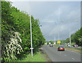
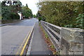
A539 looking west from A483 slip road
The slip road leaves the A483 here at the Ruabon junction.
Image: © John Firth
Taken: 9 May 2011
0.04 miles
2
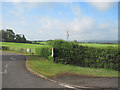
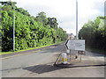
Exit from James Farm caravan site
At junction with A539
Image: © John Firth
Taken: 9 May 2011
0.07 miles
3
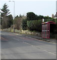
Bridge Street bus stop and shelter, Ruabon
Alongside the B5605 Bridge Street near the Duke Street and Station Road junctions.
Image: © Jaggery
Taken: 27 Feb 2016
0.10 miles
4
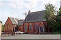
Disused church, Ruabon
Situated on Bridge Street, opposite Station Road, at the junction with Duke Street. The building is of mid 19th-early 20th century red-brick design, and the windows are boarded and bricked up. I think it was a Methodist chapel?
Image: © El Pollock
Taken: 11 Jun 2014
0.10 miles
5
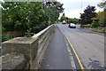
Old Milestones
Old milestones on what would have been the A539 on the pillars at each end of a bridge over the Afon Eitha at Ruabon, Wrexham. For overall views see http://www.geograph.org.uk/photo/5580343 and for the other three pillars see http://www.geograph.org.uk/photo/5579851
http://www.geograph.org.uk/photo/5579856 http://www.geograph.org.uk/photo/5580330 http://www.geograph.org.uk/photo/5580334
Image: © Keith Evans
Taken: 23 Sep 2017
0.11 miles
6
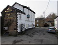
Duke of Wellington, Ruabon
Marston's pub in Duke Street, on the corner of Paddock Row.
http://www.geograph.org.uk/photo/4843202 to a closer view of name sign
Image: © Jaggery
Taken: 27 Feb 2016
0.11 miles
7
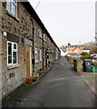
Paddock Row towards Duke Street, Ruabon
Long row of houses on the east side of Duke Street.
Image: © Jaggery
Taken: 27 Feb 2016
0.11 miles
9
Old Milestones
Old milestones on what would have been the A539 on the pillars at each end of a bridge over the Afon Eitha at Ruabon, Wrexham. For overall views see http://www.geograph.org.uk/photo/5580347 and for the other three pillars see http://www.geograph.org.uk/photo/5579851
http://www.geograph.org.uk/photo/5579856 http://www.geograph.org.uk/photo/5580330 http://www.geograph.org.uk/photo/5580334
Image: © Keith Evans
Taken: 23 Sep 2017
0.12 miles
10
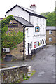
The Duke of Wellington, Ruabon
This Marston's house on Duke Street is one of several pubs in Ruabon.
Image: © Stephen McKay
Taken: 9 May 2019
0.12 miles