IMAGES TAKEN NEAR TO
Lower School Drive, WREXHAM, LL14 6RP
Introduction
This page details the photographs taken nearby to Lower School Drive, LL14 6RP by members of the Geograph project.
The Geograph project started in 2005 with the aim of publishing, organising and preserving representative images for every square kilometre of Great Britain, Ireland and the Isle of Man.

There are currently over 7.5m images from over14,400 individuals and you can help contribute to the project by visiting https://www.geograph.org.uk
Image Map
Images are licensed for reuse under creativecommons.org/licenses/by-sa/2.0
Notes
- Clicking on the map will re-center to the selected point.
- The higher the marker number, the further away the image location is from the centre of the postcode.
Image Listing (64 Images Found)
Images are licensed for reuse under creativecommons.org/licenses/by-sa/2.0
Image
Details
Distance
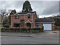
1
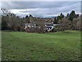
Ty'n Yr Ysgol, Ruabon
I think this is an old grammar school which has now been converted.
Image: © TCExplorer
Taken: 4 Mar 2024
0.05 miles
7
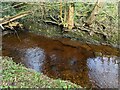
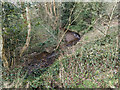
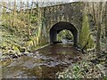
Orange coloured water of the Afon Eitha
Near to Tatham Bridge. Probably the colour is influenced by the historical industrial activity (mining) of the area.
Image: © TCExplorer
Taken: 4 Mar 2024
0.14 miles