IMAGES TAKEN NEAR TO
Dennis Court, WREXHAM, LL14 6NB
Introduction
This page details the photographs taken nearby to Dennis Court, LL14 6NB by members of the Geograph project.
The Geograph project started in 2005 with the aim of publishing, organising and preserving representative images for every square kilometre of Great Britain, Ireland and the Isle of Man.

There are currently over 7.5m images from over14,400 individuals and you can help contribute to the project by visiting https://www.geograph.org.uk
Image Map (Loading...)


Getting Data...Please wait
Leaflet Map data © OpenStreetMap
Images are licensed for reuse under creativecommons.org/licenses/by-sa/2.0
Notes
- Clicking on the map will re-center to the selected point.
- The higher the marker number, the further away the image location is from the centre of the postcode.
Image Listing (226 Images Found)
Images are licensed for reuse under creativecommons.org/licenses/by-sa/2.0
Image
Details
Distance
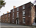
1
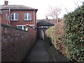
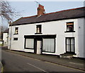
Urban footpath
This footpath has come from open country on Wat's Dyke to the confines of the buildings on a village high street. The barred building on the left is the HSBC bank with offices to the right.
Image: © John Haynes
Taken: 24 Mar 2012
0.01 miles
2
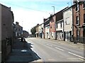
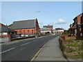
Stryt Fawr, Rhiwabon
Ruabon's High Street, once the very busy main A483, now something of a backwater.
Image: © Mike Parker
Taken: 1 Mar 2022
0.02 miles
3
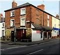
Corner barber shop in Ruabon
Named Grade One, the barber shop is on the corner of High Street (on the right) and Church Street.
Image: © Jaggery
Taken: 27 Feb 2016
0.03 miles
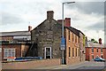
4
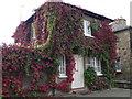
The Gate House, Ruabon
The Gate House stands next to Ruabon Gates, the Ruabon entrance to the Wynnstay Park.Image
Image: © Eirian Evans
Taken: 26 Sep 2007
0.03 miles
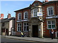
6
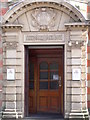
Impressive doorway for HSBC Bank
The North and South Wales Bank dates from around the time Queen Victoria came to the throne. Many local banks were set up in the 18th and 19th century and used to issue their own notes because of the danger of transporting bank notes from London. The bank became a public company in early 20th Century and was amalgamated as part of the Midland Bank and latterly HSBC.
Why it was called the North and South Wales Bank is a mystery - it was a local bank with branches in far off places such as Porthmadog and Holyhead and the furthest east it went was Liverpool (honorary Wales!). The notes from such banks were only ever meant to be used locally and the banks were often owned by single or groups of local businessmen. The last Welsh banknotes (from this bank) were withdrawn in 1908
Image: © Eirian Evans
Taken: 19 Mar 2008
0.03 miles
7
Wynnstay Arms, High Street, Ruabon
Situated on the B5605, looking south.
Image: © El Pollock
Taken: 11 Jun 2014
0.03 miles
8
Southern end of High Street, Ruabon
Part of the Wynnstay Arms Hotel, http://www.geograph.org.uk/photo/4845542 on the corner of Park Street, is on the right.
Image: © Jaggery
Taken: 27 Feb 2016
0.03 miles
9
Exchange Building, Ruabon
Viewed across Church Street near the corner of High Street.
The Exchange Building is opposite Grade I listed St Mary's Church. http://www.geograph.org.uk/photo/4846580
Image: © Jaggery
Taken: 27 Feb 2016
0.03 miles
10
High Street, Ruabon
The B5605 through Ruabon. On the left is Ruabon Methodist Church, formerly a Primitive Methodist Sunday School built in 1892.
Image: © Eirian Evans
Taken: 19 Mar 2008
0.04 miles