IMAGES TAKEN NEAR TO
Maes Mabon, WREXHAM, LL14 6EL
Introduction
This page details the photographs taken nearby to Maes Mabon, LL14 6EL by members of the Geograph project.
The Geograph project started in 2005 with the aim of publishing, organising and preserving representative images for every square kilometre of Great Britain, Ireland and the Isle of Man.

There are currently over 7.5m images from over14,400 individuals and you can help contribute to the project by visiting https://www.geograph.org.uk
Image Map (Loading...)


Getting Data...Please wait
Leaflet Map data © OpenStreetMap
Images are licensed for reuse under creativecommons.org/licenses/by-sa/2.0
Notes
- Clicking on the map will re-center to the selected point.
- The higher the marker number, the further away the image location is from the centre of the postcode.
Image Listing (20 Images Found)
Images are licensed for reuse under creativecommons.org/licenses/by-sa/2.0
Image
Details
Distance
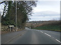
1
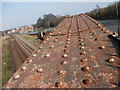
Railway bridge at Rhiwabon
The A539 road bridge over the Shrewsbury to Chester railway is original and made if riveted plates. This is the top of the arch from the road pavement. The houses to the left are Gerddi Wynnstay.
Image]
Image: © John Haynes
Taken: 24 Mar 2012
0.05 miles
2
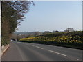
Bank of daffodils
Always the sign that spring is about to happen, this bank looks good year after year.
Image: © John Haynes
Taken: 24 Mar 2012
0.06 miles
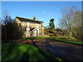
3
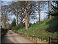
What a garden feature
Tir y Fron has a scheduled monument beside the drive. This piece of Clawdd Offa (Offa's Dyke) has obviously been "gardened" for many years.
Image: © John Haynes
Taken: 24 Mar 2012
0.09 miles
4
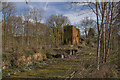
Wynnstay Colliery
The remnants of the old Wynnstay colliery, cut in two sometime in the 1970's when the main road was altered to avoid a dangerous bend known as 'The Green Corner'.
Image: © Geraint Roberts
Taken: 13 Apr 2016
0.10 miles
6
Boarded house near Ruabon
Seems like a nice house, wonder why it's unoccupied? Ideal for railbuffs as it backs onto the railway.
Image: © John Lucas
Taken: 14 Jan 2016
0.11 miles
7
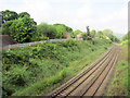
Railway south of Ruabon station
Looking south from A539 bridge towards Chirk
Image: © John Firth
Taken: 9 May 2011
0.12 miles
8
Rhiwabon village sign
This is one of several "colliery" community signs that have been commissioned to commemorate the North East Wales coalfield.
Image]
Image]
Image]
Image: © John Haynes
Taken: 24 Mar 2012
0.15 miles
9
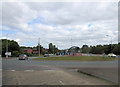
A539 roundabout junction with B5605
To the left is Bridge Street and, on the right of the picture, it's nice to see the 1960's - Ford 105E Anglia - bridging the years .
Image: © Stuart Logan
Taken: 20 Sep 2013
0.16 miles
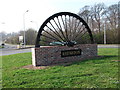
10
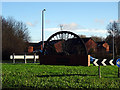
The 'Ruabon Wheel'
A reminder of a mining past. Located on the roundabout on the A539 road, south-west of the town.
Image: © John Lucas
Taken: 14 Jan 2016
0.16 miles