IMAGES TAKEN NEAR TO
Stanley Grove, WREXHAM, LL14 6AH
Introduction
This page details the photographs taken nearby to Stanley Grove, LL14 6AH by members of the Geograph project.
The Geograph project started in 2005 with the aim of publishing, organising and preserving representative images for every square kilometre of Great Britain, Ireland and the Isle of Man.

There are currently over 7.5m images from over14,400 individuals and you can help contribute to the project by visiting https://www.geograph.org.uk
Image Map (Loading...)


Getting Data...Please wait
Leaflet Map data © OpenStreetMap
Images are licensed for reuse under creativecommons.org/licenses/by-sa/2.0
Notes
- Clicking on the map will re-center to the selected point.
- The higher the marker number, the further away the image location is from the centre of the postcode.
Image Listing (17 Images Found)
Images are licensed for reuse under creativecommons.org/licenses/by-sa/2.0
Image
Details
Distance
2
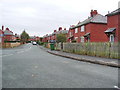
Well established housing estate
Built when estates gave you air to breath.
Image: © John Haynes
Taken: 24 Mar 2012
0.08 miles
3
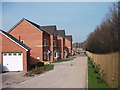
Llys Woodbank Rhiwabon
These new houses have been squeezed into a space between the A483 and an established estate. The house attached to the garage on the left is the sales "show house".
Image: © John Haynes
Taken: 24 Mar 2012
0.16 miles
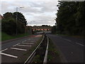
5
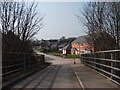
View across the accommodation bridge
The bridge rises steeply in the middle so this view slowly appears as you walk over. Image]
The new houses on the right include the sales "show house" of a small development hidden from view. Image]
The houses with the roof top solar panels are to "senior" bungalows on a local authority estate.
Image: © John Haynes
Taken: 24 Mar 2012
0.17 miles
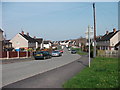
6
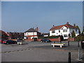
Houses & shops on Rhiwabon high street
The A483 used to pass through here, now it is just a busy village centre. Large house to the right, shops to left (looking very like houses) and the large terrace houses beyond would have been "best end" housing pre-1939.
Image: © John Haynes
Taken: 24 Mar 2012
0.17 miles
8
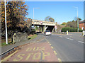
Railway crosses the B 5605
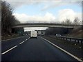
The current B 5605 used to be the Chester to Shrewsbury road (A 483 T) and at Wynnville halt the Chester to Shrewsbury railway crossed the road. In an attempt to allow bigger vehicles passage the road was lowered and the bridge held up on concrete rafts. The A 483 road has now by-passed Ruabon and this road is just a local service road.
Image: © John Haynes
Taken: 9 Oct 2005
0.18 miles
9
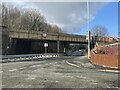
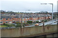
Railway bridge over the B5605
North of Ruabon station.
Image: © John H Darch
Taken: 22 Feb 2022
0.19 miles