IMAGES TAKEN NEAR TO
Highfields, WREXHAM, LL14 5NU
Introduction
This page details the photographs taken nearby to Highfields, LL14 5NU by members of the Geograph project.
The Geograph project started in 2005 with the aim of publishing, organising and preserving representative images for every square kilometre of Great Britain, Ireland and the Isle of Man.

There are currently over 7.5m images from over14,400 individuals and you can help contribute to the project by visiting https://www.geograph.org.uk
Image Map
Images are licensed for reuse under creativecommons.org/licenses/by-sa/2.0
Notes
- Clicking on the map will re-center to the selected point.
- The higher the marker number, the further away the image location is from the centre of the postcode.
Image Listing (7 Images Found)
Images are licensed for reuse under creativecommons.org/licenses/by-sa/2.0
Image
Details
Distance
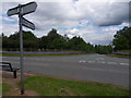
1
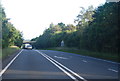
Coming up the bank out of England
Just beyond the over bridge in the distance is the Glyn Ceiriog high bridge which takes the A5 over the Afon Ceiriog which is the Welsh border.
Image: © John Haynes
Taken: 22 Oct 2005
0.06 miles
2
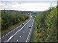
Monument to the mining industry
Part of a coal cutting machine on Chirk Green
Image: © Geraint Roberts
Taken: 4 Jun 2015
0.13 miles
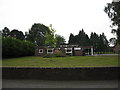
3
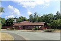
Chirk fire station
At the junction of Lloyd's Lane and Colliery Road
Image: © Eirian Evans
Taken: 19 Jul 2018
0.22 miles
4
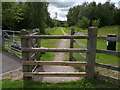
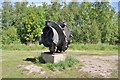
Chirk Green
Footpath access gate to Chirk Green, a green open space featuring disused mine shafts.
Image: © J Scott
Taken: 29 Jun 2011
0.24 miles
6
Pont y Blew
Bridge over the A483 at Chirk Green.
Image: © J Scott
Taken: 29 Jun 2011
0.24 miles