IMAGES TAKEN NEAR TO
Bramblewood Court, WREXHAM, LL14 5LJ
Introduction
This page details the photographs taken nearby to Bramblewood Court, LL14 5LJ by members of the Geograph project.
The Geograph project started in 2005 with the aim of publishing, organising and preserving representative images for every square kilometre of Great Britain, Ireland and the Isle of Man.

There are currently over 7.5m images from over14,400 individuals and you can help contribute to the project by visiting https://www.geograph.org.uk
Image Map (Loading...)


Getting Data...Please wait
Leaflet Map data © OpenStreetMap
Images are licensed for reuse under creativecommons.org/licenses/by-sa/2.0
Notes
- Clicking on the map will re-center to the selected point.
- The higher the marker number, the further away the image location is from the centre of the postcode.
Image Listing (28 Images Found)
Images are licensed for reuse under creativecommons.org/licenses/by-sa/2.0
Image
Details
Distance
1
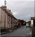
Quinta Terrace houses in Chirk Bank
Row of six houses between Bramblewood Close and Trehowell Avenue.
Image: © Jaggery
Taken: 16 Oct 2014
0.02 miles
2
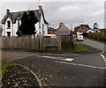
Victorian detached house on a corner in Chirk Bank
The year 1872 is inscribed on a gable of South View,
the house on the corner of Quinta Terrace and Bramblewood Close.
Image: © Jaggery
Taken: 16 Oct 2014
0.03 miles
4
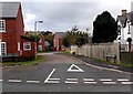
Four road signs alongside Quinta Terrace, Chirk Bank
Opposite Bramblewood Close. http://www.geograph.org.uk/photo/4286773
Image: © Jaggery
Taken: 16 Oct 2014
0.04 miles
5
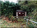
Quinta Terrace gas installation in Chirk Bank
The Wales & West Utilities gas installation is located below Quinta Terrace, opposite the Bramblewood Close junction.
Image: © Jaggery
Taken: 16 Oct 2014
0.04 miles
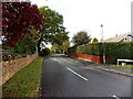
6
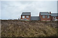
Bramblewood Close, Chirk Bank
Viewed across Quinta Terrace.
Image: © Jaggery
Taken: 16 Oct 2014
0.04 miles
7
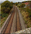
Railway from Chirk Bank towards Chirk
Viewed from Old Chirk Road railway bridge http://www.geograph.org.uk/photo/4586707 looking NNW along the Shrewsbury to Chester Line.
Chirk railway station is about 1.5km (nearly a mile) from the bridge.
Image: © Jaggery
Taken: 16 Oct 2014
0.05 miles
8
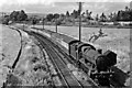
Sunday Birkenhead - Paddington express approaching Weston Rhyn
View northward, towards Wrexham, Chester and Birkenhead; ex-GWR Birmingham - Shrewsbury - Chester main line. The 14.55 from Birkenhead Woodside will eventually reach Paddington at 21.25: 'Modified Hall' 4-6-0 No. 6971 'Athelhampton Hall' (built 10/47, withdrawn 10/64) was working it between Chester and (probably) Wolverhampton. The train has just crossed the Chirk Viaduct over the River Ceiriog, which marks the 'international' boundary between Wales (Denbighshire) and England (Shropshire) and having passed the site of Trehowell Halt (open only 27/7/35 - 29/10/51). Weston Rhyn station was 'Preesgweene' until 1935 and was closed 12/9/60. In the distance is Ruabon Mountain.
Image: © Ben Brooksbank
Taken: 5 Aug 1951
0.06 miles
9
Trehowell Avenue, Chirk Bank
Viewed from the corner of Quinta Terrace.
Image: © Jaggery
Taken: 16 Oct 2014
0.07 miles
10
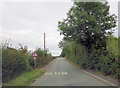
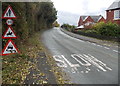
Old Chirk Road crosses the railway
The railway under the bridge runs from Shrewsbury to Wrexham.
Image: © Stuart Logan
Taken: 20 Sep 2013
0.08 miles