IMAGES TAKEN NEAR TO
Holyhead Road, WREXHAM, LL14 5HP
Introduction
This page details the photographs taken nearby to Holyhead Road, LL14 5HP by members of the Geograph project.
The Geograph project started in 2005 with the aim of publishing, organising and preserving representative images for every square kilometre of Great Britain, Ireland and the Isle of Man.

There are currently over 7.5m images from over14,400 individuals and you can help contribute to the project by visiting https://www.geograph.org.uk
Image Map
Images are licensed for reuse under creativecommons.org/licenses/by-sa/2.0
Notes
- Clicking on the map will re-center to the selected point.
- The higher the marker number, the further away the image location is from the centre of the postcode.
Image Listing (5 Images Found)
Images are licensed for reuse under creativecommons.org/licenses/by-sa/2.0
Image
Details
Distance
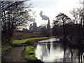
4
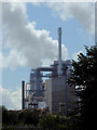
Industrial works near Chirk, Wrexham
A telephoto assisted image seen from the Llangollen Canal south of Chirk Marina. The tall structure shown is part of the Kronospan wood products site.
Image: © Roger D Kidd
Taken: 21 Sep 2015
0.22 miles
5
On the tow path of the Llangollen Canal
Chirk Kronospan board manufacturing plant is in view.
Image: © John Lucas
Taken: 14 Jan 2016
0.25 miles