IMAGES TAKEN NEAR TO
Fron Isaf, WREXHAM, LL14 5AH
Introduction
This page details the photographs taken nearby to Fron Isaf, LL14 5AH by members of the Geograph project.
The Geograph project started in 2005 with the aim of publishing, organising and preserving representative images for every square kilometre of Great Britain, Ireland and the Isle of Man.

There are currently over 7.5m images from over14,400 individuals and you can help contribute to the project by visiting https://www.geograph.org.uk
Image Map (Loading...)


Getting Data...Please wait
Leaflet Map data © OpenStreetMap
Images are licensed for reuse under creativecommons.org/licenses/by-sa/2.0
Notes
- Clicking on the map will re-center to the selected point.
- The higher the marker number, the further away the image location is from the centre of the postcode.
Image Listing (15 Images Found)
Images are licensed for reuse under creativecommons.org/licenses/by-sa/2.0
Image
Details
Distance
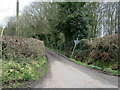
2
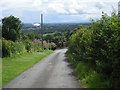
Phone box & post box at the junction
In the middle distance is the wood pulping factory at Chirk & far away on the horizon is the hill of Mow Cop near Stoke on Trent.
Image: © Row17
Taken: 6 Jul 2008
0.03 miles
4
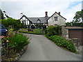
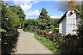
Fron Isaf from the Chirk castle road
Small community hanging on the side of the hill. 100m higher than the canal, it's all narrow roads and sharp bends. Magic.
Image: © John Haynes
Taken: 23 Oct 2005
0.03 miles
5
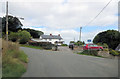
Junction of minor roads near Wern Wood
Image: © John H Darch
Taken: 21 Mar 2019
0.10 miles
6
Offa's Dyke Path near Fron Isaf
Offa's Dyke Path heading north towards the small hamlet of Fron Isaf to the north of Caeaugwynion.
Image: © Jeff Buck
Taken: 27 Aug 2015
0.10 miles
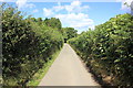
7
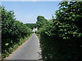
Lane near Wern Wood
Narrow lane between Wern Wood and Fron Isaf that has been adopted by the Offa's Dyke National Trail.
Image: © Chris Heaton
Taken: 27 Jul 2008
0.15 miles
8
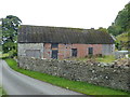
Listed barn at Fron Uchaf Farm
This barn, and the adjacent garden wall, were Grade II listed https://www.britishlistedbuildings.co.uk/300020262-farm-building-at-fron-uchaf-farm-with-front-garden-wall-chirk#.Wh-0QoZl-M8 in 1998. The timber-framed part of the barn is perhaps 17th or 18th century, and was formerly more extensive, but this appears to have been replaced with brickwork in the 19th.
Image: © Richard Law
Taken: 19 Sep 2017
0.18 miles
9
Offa's Dyke Path at Fron Cottage
Offa's Dyke Path passing Fron Cottage as it heads north near Caeaugwynion.
Image: © Jeff Buck
Taken: 27 Aug 2015
0.18 miles
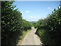
10
Narrow lane to Fron Cottage, near Fron Isaf
Fron = Hillside, slope.
Image: © Tim Heaton
Taken: 27 Jul 2008
0.18 miles