IMAGES TAKEN NEAR TO
Trefynant Park, WREXHAM, LL14 3SW
Introduction
This page details the photographs taken nearby to Trefynant Park, LL14 3SW by members of the Geograph project.
The Geograph project started in 2005 with the aim of publishing, organising and preserving representative images for every square kilometre of Great Britain, Ireland and the Isle of Man.

There are currently over 7.5m images from over14,400 individuals and you can help contribute to the project by visiting https://www.geograph.org.uk
Image Map
Images are licensed for reuse under creativecommons.org/licenses/by-sa/2.0
Notes
- Clicking on the map will re-center to the selected point.
- The higher the marker number, the further away the image location is from the centre of the postcode.
Image Listing (22 Images Found)
Images are licensed for reuse under creativecommons.org/licenses/by-sa/2.0
Image
Details
Distance
2
Old Milestone
Old mile next to the A539 at Acrefair, Wrexham. For close up view see http://www.geograph.org.uk/photo/5579838
Image: © Keith Evans
Taken: 23 Sep 2017
0.04 miles
3
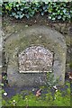
Old Milestone
Old Milestone on the A539 at Acrefair, Wrexham. For overall view see http://www.geograph.org.uk/photo/5579840.
Inscription reads:-
WREXHAM DISTRICT
TO
RUABON 2
LLANGOLLEN 4
RUTHIN 17
Milestone Society National ID: DEN_RBRU02
Image: © Keith Evans
Taken: 23 Sep 2017
0.05 miles
4
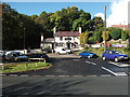
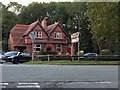
The Duke of Wellington
Village Pub in Trevor, a traditional pub that is surviving in these difficult times. Plenty of parking, garden, smoke tent and a good selection of beers, what more could you ask?
Image: © John Haynes
Taken: 12 Oct 2012
0.05 miles
5
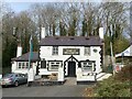
The Duke of Wellington
Pub adjacent to the A539.
Image: © John H Darch
Taken: 24 Nov 2021
0.05 miles
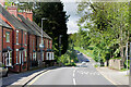
7
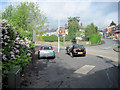
Trefynant park junction with A539
Llangollen road Acrefair
Image: © John Firth
Taken: 9 May 2011
0.07 miles
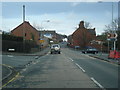
8
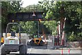
Demolition of the Monsanto Bridge
The removal of the old railway bridge that carried the Ruabon goods line. The road led to the old Monsanto Chemical Works and was locally known as Monsanto Bridge.
Image: © Geraint Roberts
Taken: 21 Jul 2015
0.07 miles
9
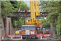
The old Monsanto Bridge
another picture of the demolition of the old railway bridge over the entrance to the former Monsanto Chemical Works
Image: © Geraint Roberts
Taken: 23 Jul 2015
0.07 miles