IMAGES TAKEN NEAR TO
New Road, Trevor Isa, WREXHAM, LL14 3NW
Introduction
This page details the photographs taken nearby to New Road, Trevor Isa, LL14 3NW by members of the Geograph project.
The Geograph project started in 2005 with the aim of publishing, organising and preserving representative images for every square kilometre of Great Britain, Ireland and the Isle of Man.

There are currently over 7.5m images from over14,400 individuals and you can help contribute to the project by visiting https://www.geograph.org.uk
Image Map (Loading...)


Getting Data...Please wait
Leaflet Map data © OpenStreetMap
Images are licensed for reuse under creativecommons.org/licenses/by-sa/2.0
Notes
- Clicking on the map will re-center to the selected point.
- The higher the marker number, the further away the image location is from the centre of the postcode.
Image Listing (119 Images Found)
Images are licensed for reuse under creativecommons.org/licenses/by-sa/2.0
Image
Details
Distance
1
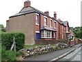
Holly Cottage at Trevor-isaf
A wonderful late Victorian detached house which was probably built for a senior local worker.
Image: © John Haynes
Taken: 27 May 2016
0.01 miles
2
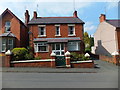
Row of Victorian houses
This heavily industrialised village expanded rapidly during the 19th Century, and this a typical group of houses from that time. The houses in the distance are in the other side of the village.
Image]
Image: © John Haynes
Taken: 30 Aug 2016
0.01 miles
3
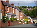
Row of houses at Cefn Mawr, Denbighshire
Image: © nick macneill
Taken: 1 Jun 2010
0.01 miles
4
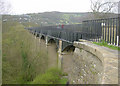
Pontcysyllte Aqueduct
The Pontcysyllte Aqueduct takes the Llangollen Canal across the valley of the River Dee. Looking southwards from Trevor.
Image: © Martin Clark
Taken: Unknown
0.11 miles
5
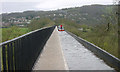
Pontcysyllte Aqueduct
Looking south along the 1000 foot long Pontcysyllte Aqueduct, 125 feet above the valley floor.
Image: © Martin Clark
Taken: Unknown
0.11 miles
7
Funding details
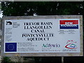
Notice board at Trevor Basin - funding partners for rural tourism
Image: © Charles Rawding
Taken: 27 Jul 2005
0.11 miles
8
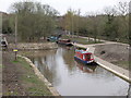
Brick Works Basin, Trefor
The brickworks basin has recently been dredged and given a good tidy up. New paths, grass areas and picnic benches have been installed.
Image: © John Haynes
Taken: 8 Apr 2004
0.11 miles
9

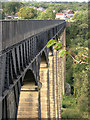
Pont Cysyllte aqueduct
The undated plaque nearby says: "Built by Thomas Telford 1795-1805 there are 18 piers made of local stone, the central ones over the Dee being 126' high up to the ironwork.
The canal runs through an iron trough, 1007' long, 11'10" wide and 5'3" deep, the largest in Britain. The iron was supplied by William Hazeldine from his foundries at Shrewsbury and nearby Cefn Mawr.
Total cost £47,000
Water is fed from the Dee at the Horseshoe falls at Llantysilio near Llangollen."
Image: © Peter Craine
Taken: 8 Jun 2006
0.11 miles