IMAGES TAKEN NEAR TO
Short Lane, WREXHAM, LL14 3JL
Introduction
This page details the photographs taken nearby to Short Lane, LL14 3JL by members of the Geograph project.
The Geograph project started in 2005 with the aim of publishing, organising and preserving representative images for every square kilometre of Great Britain, Ireland and the Isle of Man.

There are currently over 7.5m images from over14,400 individuals and you can help contribute to the project by visiting https://www.geograph.org.uk
Image Map (Loading...)


Getting Data...Please wait
Leaflet Map data © OpenStreetMap
Images are licensed for reuse under creativecommons.org/licenses/by-sa/2.0
Notes
- Clicking on the map will re-center to the selected point.
- The higher the marker number, the further away the image location is from the centre of the postcode.
Image Listing (29 Images Found)
Images are licensed for reuse under creativecommons.org/licenses/by-sa/2.0
Image
Details
Distance
2
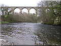
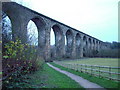
Cefn railway viaduct over river Dee
Welsh Dee with Cefn viaduct in background
Image: © David Wild
Taken: 10 Apr 2004
0.09 miles
3
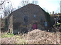
Derelict Baptist Chapel
The chapel is for sale but there are some restrictions on what can be done to convert it to a dwelling.
Image: © John Haynes
Taken: 26 Mar 2012
0.10 miles
5

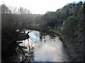
Ponies grazing in the Ceiriog valley
Afon Ceiriog flows left to right through the trees in the distance.
Image: © John Haynes
Taken: 26 Mar 2012
0.12 miles
7
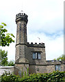
Waterloo Tower, Newbridge
A gothick tower lodge, originally one of the lodges to Wynnstay Hall, but now separated from it by the A483.
Image: © Alan Terrill
Taken: 21 May 2015
0.13 miles
8
Old Milestone by the B5605, Newbridge Road, Cefn-bychan
Wrexham plate by the B5605, in parish of Cefn (Denbighshire District), Cefn-bychan, back to stone wall.
Inscription reads:-
WREXHAM DISTRICT
TO
WREXHAM 7
RUABON 2
OSWESTRY 8
Surveyed
Milestone Society National ID: DEN_WROW07
Image: © Milestone Society
Taken: Unknown
0.14 miles
9
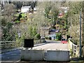
Closed road, Newbridge
In early 2021, the B5605 - formerly the main A483 - suffered a landslide just behind where I'm standing here. The road has been closed since, and there is still no agreement on funding to restore it.
Image: © Mike Parker
Taken: 1 Mar 2022
0.14 miles
10
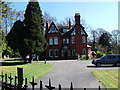
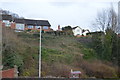
Large house tucked under the railway embankment
The Shrewsbury to Chester railway crosses the Afon Dyfrdwy by a viaduct and this house is next to the northern embankment.
Image: © John Haynes
Taken: 26 Mar 2012
0.15 miles