IMAGES TAKEN NEAR TO
Aled, WREXHAM, LL14 3HB
Introduction
This page details the photographs taken nearby to Aled, LL14 3HB by members of the Geograph project.
The Geograph project started in 2005 with the aim of publishing, organising and preserving representative images for every square kilometre of Great Britain, Ireland and the Isle of Man.

There are currently over 7.5m images from over14,400 individuals and you can help contribute to the project by visiting https://www.geograph.org.uk
Image Map
Images are licensed for reuse under creativecommons.org/licenses/by-sa/2.0
Notes
- Clicking on the map will re-center to the selected point.
- The higher the marker number, the further away the image location is from the centre of the postcode.
Image Listing (14 Images Found)
Images are licensed for reuse under creativecommons.org/licenses/by-sa/2.0
Image
Details
Distance
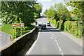
1
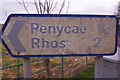
Plas Bennion Road - sign to Penycae and Rhos
This signpost at the junction of Plas Bennion Road and Llangollen Road (A539) is well past its best and clearly in need of replacement. The white background is badly crazed and the lettering is faded and virtually illegible to passing traffic. See Image for the context and an illustration of how difficult this sign is for motorists to see.
Image: © Stephen McKay
Taken: 19 Feb 2019
0.08 miles
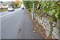
2
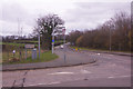
Llangollen Road, west of Ruabon
Looking along the A539 towards Ruabon with Plas Bennion Road leading off to the left.
Image: © Stephen McKay
Taken: 19 Feb 2019
0.10 miles
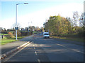
3

Bus Stop on Llangollen Road
Arriva Midlands 3755 (YJ59 BUW), aVDL SB200/Wright Pulsar stands at a bus stop on the A539 between Ruabon and Plas Madoc.
Image: © David Dixon
Taken: 15 May 2023
0.10 miles
4
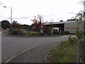
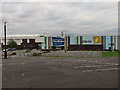
Factory on The Wynnstay Technology Park
Factory site in the area of the old Wynnstay colliery.
Image: © John Haynes
Taken: 23 Oct 2005
0.11 miles
5
Old Milestone
Old Milestone on the A539 near to Ruabon, Wrexham. For overall view see http://www.geograph.org.uk/photo/5579836
Image: © Keith Evans
Taken: 23 Sep 2017
0.12 miles
6
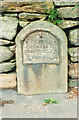
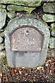
Old Milestone by the A539, Llangollen Road, Plas Madoc
Wrexham plate by the A539, in parish of Cefn (Wrexham County Borough District), Plas-yn-Wern, opposite Plas Madoc Leisure Centre, set in wall.
Inscription reads:-
WREXHAM DISTRICT
TO
RUABON 1
LLANGOLLEN 5
RUTHIN 18
Surveyed
Milestone Society National ID: DEN_RBRU01
Image: © Milestone Society
Taken: Unknown
0.12 miles
7
Old Milestone
Old mile next to the A539 near to Cefn-Mawr, Wrexham. For close up view see http://www.geograph.org.uk/photo/5579835
Image: © Keith Evans
Taken: 23 Sep 2017
0.15 miles
10
Plas Madoc Leisure Centre
Plas Madoc is a community on the Ruabon to Llangollen road but still within Wrecsam County Borough.
Image: © John Haynes
Taken: 18 Sep 2005
0.18 miles