IMAGES TAKEN NEAR TO
Tan Y Clawdd, WREXHAM, LL14 2ST
Introduction
This page details the photographs taken nearby to Tan Y Clawdd, LL14 2ST by members of the Geograph project.
The Geograph project started in 2005 with the aim of publishing, organising and preserving representative images for every square kilometre of Great Britain, Ireland and the Isle of Man.

There are currently over 7.5m images from over14,400 individuals and you can help contribute to the project by visiting https://www.geograph.org.uk
Image Map
Images are licensed for reuse under creativecommons.org/licenses/by-sa/2.0
Notes
- Clicking on the map will re-center to the selected point.
- The higher the marker number, the further away the image location is from the centre of the postcode.
Image Listing (16 Images Found)
Images are licensed for reuse under creativecommons.org/licenses/by-sa/2.0
Image
Details
Distance
1
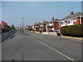
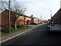
Houses on Bangor Road
Much modified 1930's semis, the front hall and the kitchen was very small in these houses (reproduced all over the UK) and many variations of retro fitted doorways are in evidence here.
Image: © John Haynes
Taken: 24 Mar 2012
0.05 miles
2
Road junction at Johnstown
On B5605. Turnoff right at traffic lights to Bangor on Dee
Image: © John Firth
Taken: 10 Nov 2010
0.07 miles
3
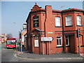
Accountants in the pub
Sadly this pub no longer sells beer but a firm of business accountants use the premises.
Image: © John Haynes
Taken: 24 Mar 2012
0.08 miles
4
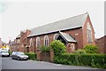
Christchurch United Reformed Church, Johnstown
Its full title is "Christchurch United Reformed Church in Jerusalem". I'm not sure if it is still being used.
Image: © Peter Craine
Taken: 3 Jun 2008
0.12 miles
5
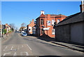
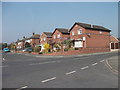
Stryt y Parc, Johnstown
A mix of various ages and types of houses.
Image: © John Haynes
Taken: 24 Mar 2012
0.13 miles
6
St. Mary's Church, Johnstown
Apparently celebrating its 80th year in 2008 -see http://www.eveningleader.co.uk/rhosmarchwiel/Johnstown--220508.4116266.jp
Image: © Peter Craine
Taken: 3 Jun 2008
0.15 miles
7
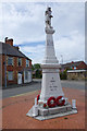
Johnstown War Memorial
The war memorial at the junction of Maelor Road and High Street was built around 1920 and includes names from the First and Second World Wars. On the top of the pillar is a statue of St Michael.
Image: © Stephen McKay
Taken: 30 May 2019
0.16 miles
8
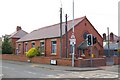
Infill modern houses
The used to be two community shops on this site, they were replaced by these houses in 2002.
Image: © John Haynes
Taken: 24 Mar 2012
0.18 miles
9
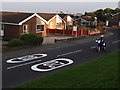
Twenty twenty vision
Just what you need when there's motorcyclists about.
Think once.
Think twice.
Think Bike!
http://www.youtube.com/watch?v=IYJYA0P5ls8
Image: © Ian Paterson
Taken: 27 Aug 2013
0.18 miles
10
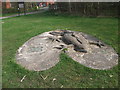
Mosaic newt on Barc Stryt Las
A mosaic of coloured stones and concrete.
Image: © John Haynes
Taken: 24 Mar 2012
0.19 miles