IMAGES TAKEN NEAR TO
Wern Las, WREXHAM, LL14 2HG
Introduction
This page details the photographs taken nearby to Wern Las, LL14 2HG by members of the Geograph project.
The Geograph project started in 2005 with the aim of publishing, organising and preserving representative images for every square kilometre of Great Britain, Ireland and the Isle of Man.

There are currently over 7.5m images from over14,400 individuals and you can help contribute to the project by visiting https://www.geograph.org.uk
Image Map
Images are licensed for reuse under creativecommons.org/licenses/by-sa/2.0
Notes
- Clicking on the map will re-center to the selected point.
- The higher the marker number, the further away the image location is from the centre of the postcode.
Image Listing (17 Images Found)
Images are licensed for reuse under creativecommons.org/licenses/by-sa/2.0
Image
Details
Distance
1
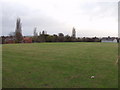
Recreation ground off Pen-y-Graig
Large open space in between the houses.
Image: © John Haynes
Taken: 10 Nov 2007
0.18 miles
2
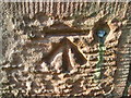
Ordnance Survey 1GL Bolt
This OS Bolt can be found on the east side of St John's Church. It marks a point 173.797m above mean sea level.
Image: © Adrian Dust
Taken: 8 Aug 2015
0.19 miles
3
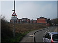
New flats on Stryt Las
New flats erected on derelict industrial land
Image: © John Haynes
Taken: 24 Mar 2012
0.21 miles
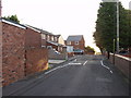
4
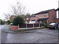
Relatively new houses on Pen-y-Graig
Infill houses and flats at the end of the street.
Image: © John Haynes
Taken: 10 Nov 2007
0.21 miles
5
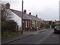
Bungalows in Pen-y-Graig
Two pairs of semi-detached bungalows, several of which have been extended.
Image: © John Haynes
Taken: 10 Nov 2007
0.22 miles
6
Ffordd y Fynwent, Rhosllannerchrugog
A pair of semi-detached and a detached house were built in 2005 on two areas of spare ground at the top of Cemetery Road.
Image: © John Haynes
Taken: 7 Oct 2006
0.22 miles
7
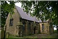
St. John's Parish Church, Rhosllanerchrugog
This was consecrated in 1853 and closed in 2004 due to lack of funding for roof repairs. The building (which is grade II listed) still appears to be in good condition.
Despite being relatively new and having excellent stone work, it has an ancient and haunting feel about it - possibly due to the Romanesque revival / Norman style of architecture and the overgrowths.
It is located next to the main cemetery (which is not accessible from here) and there are also gravestones in the church grounds which I found to be unique. Several of them are in purple slate.
I liked this place.
Image: © Peter Craine
Taken: 3 Jun 2008
0.22 miles
8
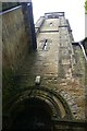
Tower of St John's Church, Rhosllanerchrugog
See Image
This picture shows the rounded archways of this disused church.
Image: © Peter Craine
Taken: 3 Jun 2008
0.22 miles
9
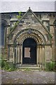
Archway of St. John's Church, Rhos
See Image
This was the main entrance.
Image: © Peter Craine
Taken: 3 Jun 2008
0.22 miles
10
Old clay pit at Johnstown
The old clay pit has now become Barc Stryt Las (Stryt Las Park) and it has matured well and the amount of wild life has increased. There is a good mix of habitat which provides an excellent local amenity.
Image]
Image: © John Haynes
Taken: 24 Mar 2012
0.23 miles