IMAGES TAKEN NEAR TO
Pant Hill, WREXHAM, LL14 2DU
Introduction
This page details the photographs taken nearby to Pant Hill, LL14 2DU by members of the Geograph project.
The Geograph project started in 2005 with the aim of publishing, organising and preserving representative images for every square kilometre of Great Britain, Ireland and the Isle of Man.

There are currently over 7.5m images from over14,400 individuals and you can help contribute to the project by visiting https://www.geograph.org.uk
Image Map (Loading...)


Getting Data...Please wait
Leaflet Map data © OpenStreetMap
Images are licensed for reuse under creativecommons.org/licenses/by-sa/2.0
Notes
- Clicking on the map will re-center to the selected point.
- The higher the marker number, the further away the image location is from the centre of the postcode.
Image Listing (6 Images Found)
Images are licensed for reuse under creativecommons.org/licenses/by-sa/2.0
Image
Details
Distance
1

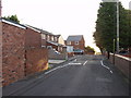
A sign of the times
Another pub bites the dust! This one was the Wheelwrights Arms at Stryt Issa. Just by walking around this area you can observe the changes in society in NE Wales. The numbers of pubs is getting less, people are drinking at home having got their pop from "Bargain Booze".
Image: © John Haynes
Taken: 23 Oct 2005
0.19 miles
2
Ffordd y Fynwent, Rhosllannerchrugog
A pair of semi-detached and a detached house were built in 2005 on two areas of spare ground at the top of Cemetery Road.
Image: © John Haynes
Taken: 7 Oct 2006
0.22 miles
3
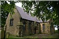
St. John's Parish Church, Rhosllanerchrugog
This was consecrated in 1853 and closed in 2004 due to lack of funding for roof repairs. The building (which is grade II listed) still appears to be in good condition.
Despite being relatively new and having excellent stone work, it has an ancient and haunting feel about it - possibly due to the Romanesque revival / Norman style of architecture and the overgrowths.
It is located next to the main cemetery (which is not accessible from here) and there are also gravestones in the church grounds which I found to be unique. Several of them are in purple slate.
I liked this place.
Image: © Peter Craine
Taken: 3 Jun 2008
0.22 miles
4
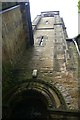
Tower of St John's Church, Rhosllanerchrugog
See Image
This picture shows the rounded archways of this disused church.
Image: © Peter Craine
Taken: 3 Jun 2008
0.22 miles
5
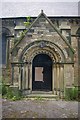
Archway of St. John's Church, Rhos
See Image
This was the main entrance.
Image: © Peter Craine
Taken: 3 Jun 2008
0.22 miles
6
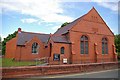
Bethania, Eglwys y Bedyddwyr, Rhosllanerchrugog
As many chapels in this area have biblical references in their names, it may be that Bethania refers to Bethany, a small village near Jerusalem.
Eglwys y Bedyddwyr means Baptist church. Members of this denomination believe that followers of Jesus Christ demonstrate their faith by being baptised (most commonly by immersion in water) and are not in favour of infant baptism.
The building is dated 1905.
Image: © Peter Craine
Taken: 3 Jun 2008
0.24 miles