IMAGES TAKEN NEAR TO
Glanrafon, WREXHAM, LL14 2DP
Introduction
This page details the photographs taken nearby to Glanrafon, LL14 2DP by members of the Geograph project.
The Geograph project started in 2005 with the aim of publishing, organising and preserving representative images for every square kilometre of Great Britain, Ireland and the Isle of Man.

There are currently over 7.5m images from over14,400 individuals and you can help contribute to the project by visiting https://www.geograph.org.uk
Image Map (Loading...)


Getting Data...Please wait
Leaflet Map data © OpenStreetMap
Images are licensed for reuse under creativecommons.org/licenses/by-sa/2.0
Notes
- Clicking on the map will re-center to the selected point.
- The higher the marker number, the further away the image location is from the centre of the postcode.
Image Listing (20 Images Found)
Images are licensed for reuse under creativecommons.org/licenses/by-sa/2.0
Image
Details
Distance
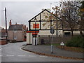
1
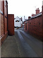
Railway Inn Rhos
The view shows the Railway Inn looking West and the narrow streets with no pavements running between the buildings made of local "Ruabon Red brick".
Image: © John Hallard
Taken: 4 Jan 2009
0.08 miles
2
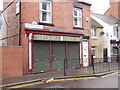
Siop-y-barbwr on Stryt y Farchnad
A traditional barber's shop on Market Street.
Image]
Image: © John Haynes
Taken: 10 Nov 2007
0.13 miles
3
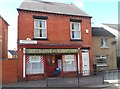
Siop-y-barbwr on Stryt y Farchnad
A traditional barber's shop on Market Street.
Image]
Image: © John Haynes
Taken: 12 Mar 2013
0.15 miles
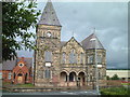
4
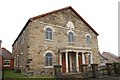
Jerusalem chapel, Rhosllanerchrugog
The inscription on the wall reads:
JERUSALEM
ADDOLDY Y
METHODISTIAID CALVINAIDD
ADEILADWYD 1770
HELAETHWYD 1837
Image: © Peter Craine
Taken: 3 Jun 2008
0.15 miles
5
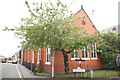
Capel Mawr, Rhosllanerchrugog
Denomination: Calvinistic Methodist.
Image: © Peter Craine
Taken: 3 Jun 2008
0.18 miles
6
Rhosllanerchrugog
Just off the A483 south of Wrexham in the village of Rhosllanerchrugog, this building, built around 1889, housed an orphanage between WW1 and WW2 - my father-in-law spent some of his boyhood there before joining the army at the age of 17 in 1927. Still has a forbidding look about it.
Image: © Patrick A Griffin
Taken: 11 Jul 2004
0.20 miles
7
Y Stiwt, Rhosllanerchrugog
This was originally the "Miners' Institute" (Plas Mwynwyr), built in 1926 and which dominated the social and cultural life of the town until 1977 when it closed. The local council, which had bought the building in 1978, decided to demolish the building in 1985, but it was saved as a result of local campaigning. Following fundraising efforts, it was renovated and reopened as a community theatre.
Image: © Eirian Evans
Taken: 19 Mar 2008
0.20 miles
8
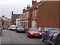
Houses on Stryt y Brenin
The houses on King Street are of various ages. Not in King Street, but stone built houses at the far end. Then a pair of harled (stone dashed) houses, with two pairs of red brick houses. Looking at the nearest house you can see the fronts were built with red facing bricks whereas the side walls were built in commons. These may have been different clay but probably bricks from the edge of the kiln which got "burnt".
Image: © John Haynes
Taken: 10 Nov 2007
0.20 miles
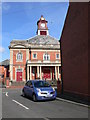
9
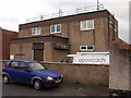
Rhosllannerchrugog telephone exchange
Local exchange with a good line of sight eastwood for the equipment on the roof. 200m from my house so I have good internet connexion.
Image: © John Haynes
Taken: 10 Nov 2007
0.21 miles
10
The Oriental Tandoori on Stryt y Gof
The Indian takeaway on Church Street used to be a fish and chip shop but now does an excellent Indian style carryout.
Image: © John Haynes
Taken: 10 Nov 2007
0.21 miles