
IMAGES TAKEN NEAR TO
Stephens Lane, WREXHAM, LL14 1BG
Introduction
This page details the photographs taken nearby to Stephens Lane, LL14 1BG by members of the Geograph project.
The Geograph project started in 2005 with the aim of publishing, organising and preserving representative images for every square kilometre of Great Britain, Ireland and the Isle of Man.

There are currently over 7.5m images from over14,400 individuals and you can help contribute to the project by visiting https://www.geograph.org.uk
Image Map
Images are licensed for reuse under creativecommons.org/licenses/by-sa/2.0
Notes
- Clicking on the map will re-center to the selected point.
- The higher the marker number, the further away the image location is from the centre of the postcode.
Image Listing (31 Images Found)
Images are licensed for reuse under creativecommons.org/licenses/by-sa/2.0
Image
Details
Distance
1
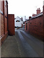
Railway Inn Rhos
The view shows the Railway Inn looking West and the narrow streets with no pavements running between the buildings made of local "Ruabon Red brick".
Image: © John Hallard
Taken: 4 Jan 2009
0.04 miles
2
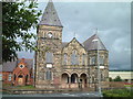
Rhosllanerchrugog
Just off the A483 south of Wrexham in the village of Rhosllanerchrugog, this building, built around 1889, housed an orphanage between WW1 and WW2 - my father-in-law spent some of his boyhood there before joining the army at the age of 17 in 1927. Still has a forbidding look about it.
Image: © Patrick A Griffin
Taken: 11 Jul 2004
0.09 miles
3
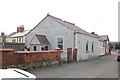
Bethel, Eglwys Disgyblion Crist, Rhosllannerchrugog
Bethel is Hebrew for "House of God".
Eglwys Disgyblion Crist means "The Church of Christ's Disciples".
Image: © Peter Craine
Taken: 3 Jun 2008
0.11 miles
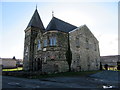
5
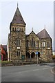
Bethlehem Chapel
Bethlehem Chapel was built 1812 and modified, altered or rebuilt in 1839, 1876 and again in 1889 (when the architect was Owen Morris Roberts of Porthmadog). There were further modifications in 1908 and 1926.
The chapel is an unusual example of the Rundbogenstil.
Grade II listed. CADW source 17090.
Image: © Richard Hoare
Taken: 8 Oct 2018
0.12 miles
6
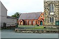
Bethlehem Chapel schoolrooms
Now disused.
The property comprises a Grade II Listed building forming
part of the featured Bethlehem Chapel next door. Image] The
Listing Entry does not refer to the school room building
specifically. Listed Building Consent was Granted for the
conversion of the building under code number
P/2014/0608. Planning permission for the development of
the building into six residential apartments was granted by
Wrexham County Borough Council under two concurrent
applications (for two apartments plus four apartments) on
the 8th August 2015 under code numbers P/2014/0606 and
P/2014/0607 respectively.
Image: © Richard Hoare
Taken: 8 Oct 2018
0.12 miles
7
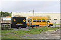
Sun Inn mobile bar
Adjacent to the Sun Inn.
Image]
Image: © Richard Hoare
Taken: 8 Oct 2018
0.13 miles
8
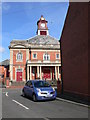
Y Stiwt, Rhosllanerchrugog
This was originally the "Miners' Institute" (Plas Mwynwyr), built in 1926 and which dominated the social and cultural life of the town until 1977 when it closed. The local council, which had bought the building in 1978, decided to demolish the building in 1985, but it was saved as a result of local campaigning. Following fundraising efforts, it was renovated and reopened as a community theatre.
Image: © Eirian Evans
Taken: 19 Mar 2008
0.13 miles
9
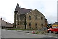
Bethlehem Chapel - side view
Bethlehem Chapel was built 1812 and modified, altered or rebuilt in 1839, 1876 and again in 1889 (when the architect was Owen Morris Roberts of Porthmadog). There were further modifications in 1908 and 1926.
The chapel is an unusual example of the Rundbogenstil.
Grade II listed. CADW source 17090.
Image: © Richard Hoare
Taken: 8 Oct 2018
0.14 miles
10
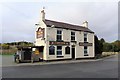
Sun Inn
A Burtonwood pub.
The pub has a mobile bar. Image]
Image: © Richard Hoare
Taken: 8 Oct 2018
0.14 miles