IMAGES TAKEN NEAR TO
Ranscombe Crescent, WREXHAM, LL13 9UX
Introduction
This page details the photographs taken nearby to Ranscombe Crescent, LL13 9UX by members of the Geograph project.
The Geograph project started in 2005 with the aim of publishing, organising and preserving representative images for every square kilometre of Great Britain, Ireland and the Isle of Man.

There are currently over 7.5m images from over14,400 individuals and you can help contribute to the project by visiting https://www.geograph.org.uk
Image Map (Loading...)


Getting Data...Please wait
Leaflet Map data © OpenStreetMap
Images are licensed for reuse under creativecommons.org/licenses/by-sa/2.0
Notes
- Clicking on the map will re-center to the selected point.
- The higher the marker number, the further away the image location is from the centre of the postcode.
Image Listing (7 Images Found)
Images are licensed for reuse under creativecommons.org/licenses/by-sa/2.0
Image
Details
Distance
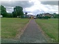
1

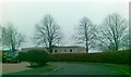
Barker's Lane, Little Acton
Smithy Lane, Box Lane and Barker's Lane meet at this roundabout in the Wrexham suburbs. The car is emerging from Barker's Lane.
Image: © Stephen McKay
Taken: 12 Feb 2019
0.03 miles
3
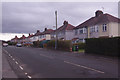
Smithy Lane, Little Acton
A row of semi-detached houses probably dating from the 1930s lines the south side of Smithy Lane; they could be in the suburbs of almost any large town or city in Wales or England. This is the view from close to the junction with Windermere Road.
Image: © Stephen McKay
Taken: 12 Feb 2019
0.18 miles
4
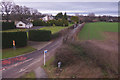
Old Wrexham Road
Old Wrexham Road leads past The Flash towards Gresford. This is the view from the footbridge over the A5156.
Image: © Stephen McKay
Taken: 12 Feb 2019
0.20 miles
6
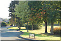
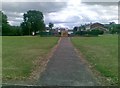
NW edge of Acton Park, Wrexham
Autumn colours just beginning to show where the park borders a residential area.
Image: © Jim Barton
Taken: 16 Sep 2009
0.23 miles