IMAGES TAKEN NEAR TO
The Oval, WREXHAM, LL13 9PU
Introduction
This page details the photographs taken nearby to The Oval, LL13 9PU by members of the Geograph project.
The Geograph project started in 2005 with the aim of publishing, organising and preserving representative images for every square kilometre of Great Britain, Ireland and the Isle of Man.

There are currently over 7.5m images from over14,400 individuals and you can help contribute to the project by visiting https://www.geograph.org.uk
Image Map (Loading...)


Getting Data...Please wait
Leaflet Map data © OpenStreetMap
Images are licensed for reuse under creativecommons.org/licenses/by-sa/2.0
Notes
- Clicking on the map will re-center to the selected point.
- The higher the marker number, the further away the image location is from the centre of the postcode.
Image Listing (5 Images Found)
Images are licensed for reuse under creativecommons.org/licenses/by-sa/2.0
Image
Details
Distance
1
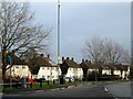
Housing at Pentre Maelor
A spacious estate, built around a huge green between 1948 - 52 for workers at the Firestone factory.
Image: © Mike Parker
Taken: 16 Feb 2022
0.05 miles
2
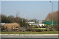
Adopted roundabout
It seems to be the policy of the local council and estate companies to adopt the maintenance of the flora on these new roundabouts.
Image: © Geoff Evans
Taken: 19 Mar 2009
0.08 miles
3
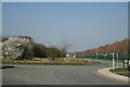
New Estate Road
Although the road appears to be fairly new, some of the trees and shrubs have been in situ for some time, particularly the ones in blossom.
Image: © Geoff Evans
Taken: 19 Mar 2009
0.08 miles
4
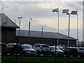
HMP Berwyn
A windy day, as can be seen by the flags flying at HMP Berwyn.
Image: © Mike Parker
Taken: 16 Feb 2022
0.18 miles
5
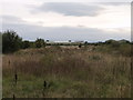
Derelict land on Wrecsam Industrial Estate
Previously used land now awaiting development.
Image: © John Haynes
Taken: 21 Sep 2005
0.23 miles