IMAGES TAKEN NEAR TO
Ceiriog Road, WREXHAM, LL13 9HY
Introduction
This page details the photographs taken nearby to Ceiriog Road, LL13 9HY by members of the Geograph project.
The Geograph project started in 2005 with the aim of publishing, organising and preserving representative images for every square kilometre of Great Britain, Ireland and the Isle of Man.

There are currently over 7.5m images from over14,400 individuals and you can help contribute to the project by visiting https://www.geograph.org.uk
Image Map (Loading...)


Getting Data...Please wait
Leaflet Map data © OpenStreetMap
Images are licensed for reuse under creativecommons.org/licenses/by-sa/2.0
Notes
- Clicking on the map will re-center to the selected point.
- The higher the marker number, the further away the image location is from the centre of the postcode.
Image Listing (11 Images Found)
Images are licensed for reuse under creativecommons.org/licenses/by-sa/2.0
Image
Details
Distance
1
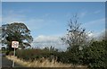
Limited Bridlepath
Difficult to distinguish where the bridleway was, but does the speed limit still apply?
Image: © Geoff Evans
Taken: 6 Oct 2011
0.06 miles
2
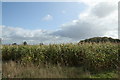
Corn on the Cob
Adjacent fields, carrying different crops.Maize here, next years wheat next door.
Image: © Geoff Evans
Taken: 6 Oct 2011
0.08 miles
3
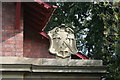
Coat of Arms
This impressive coat of arms adorns the entrance lodge to the Cefn Park Estate, home to the Fenwick-Palmer family. Is it their heraldry?
Image: © Geoff Evans
Taken: 6 Oct 2011
0.09 miles
4
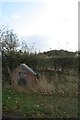
Llwyn Knottia
The rather elaborate but now looking rather sad and neglected farm name.
Image: © Geoff Evans
Taken: 6 Oct 2011
0.09 miles
5
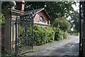
Imposing Entrance
The Wrought-iron gates, and the lodge guard the entrance to Cefn Park estate.
Image: © Geoff Evans
Taken: 6 Oct 2011
0.10 miles
6
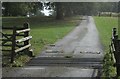
Double Indemnity
The cattle grid is protected by a "speed ramp" or sleeping policeman. No speeding cattle were in sight.
Image: © Geoff Evans
Taken: 6 Oct 2011
0.11 miles
7
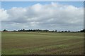
Winter Wheat
The early planting has enabled this crop to establish and appears to be very healthy for over-wintering.
Image: © Geoff Evans
Taken: 6 Oct 2011
0.12 miles
8
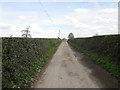
Bridleway to Llwyn Knottia
An unnamed lane/bridleway off Cefn Road to Llwyn Knottia farm.
Image: © Jeff Buck
Taken: 13 Apr 2016
0.16 miles
9
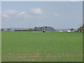
Farming on the fringe
A farm between the housing of Wrecsam (behind the photographer) and the Wrecsam Industrial Estate (far right distance). Normal spring operations have to go on.
Image: © John Haynes
Taken: 29 Apr 2006
0.17 miles
10
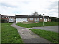
Prince Charles Road Health Centre (closed), Wrexham
The facilities at Prince Charles Road Health Centre have now transferred to the new Caia Park Surgery opposite.
Image: © Jeff Buck
Taken: 13 Apr 2016
0.24 miles