IMAGES TAKEN NEAR TO
Sutton Drive, WREXHAM, LL13 9DS
Introduction
This page details the photographs taken nearby to Sutton Drive, LL13 9DS by members of the Geograph project.
The Geograph project started in 2005 with the aim of publishing, organising and preserving representative images for every square kilometre of Great Britain, Ireland and the Isle of Man.

There are currently over 7.5m images from over14,400 individuals and you can help contribute to the project by visiting https://www.geograph.org.uk
Image Map (Loading...)


Getting Data...Please wait
Leaflet Map data © OpenStreetMap
Images are licensed for reuse under creativecommons.org/licenses/by-sa/2.0
Notes
- Clicking on the map will re-center to the selected point.
- The higher the marker number, the further away the image location is from the centre of the postcode.
Image Listing (13 Images Found)
Images are licensed for reuse under creativecommons.org/licenses/by-sa/2.0
Image
Details
Distance
1
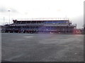
Ysgol Morgan Llwyd, Wrexham
Welsh medium secondary school with a new sixth form block being built.
Image: © Eirian Evans
Taken: 6 Feb 2019
0.07 miles
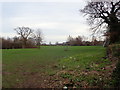
2
Countryside Croquet?
The situation of these newly planted trees and their protective frames rather resembled a rather large croquet lawn.
Image: © Geoff Evans
Taken: 6 Oct 2011
0.08 miles
3
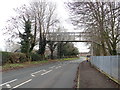
Footbridge to Freedom
This footbridge enables students of Ysgol Morgan Llwyd to reach their playing fields without endangering themselves.
Image: © Geoff Evans
Taken: 6 Oct 2011
0.12 miles
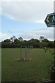
4
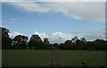
Playing Field Perspective
The path leads to the playing fields of Ysgol Morgan Llwyd.
Image: © Geoff Evans
Taken: 6 Oct 2011
0.12 miles
5
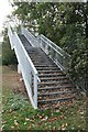
Steps to higher Education
"Health & Safety" issues not withstanding, this stairway leads students back to school after a hard session on the playing fields.
Image: © Geoff Evans
Taken: 6 Oct 2011
0.13 miles
6
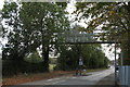
Footbridge over Cefn Road, Wrexham
Providing access to playing fields from Ysgol Morgan Llwyd
Image: © Eirian Evans
Taken: 6 Feb 2019
0.13 miles
7
School playing fields, Ysgol Morgan Llwyd
Image: © Eirian Evans
Taken: 6 Feb 2019
0.14 miles
8
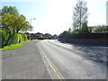
Stryt Holt (Holt Road), Wrexham
Looking south west on the A534.
Image: © JThomas
Taken: 4 May 2019
0.16 miles