IMAGES TAKEN NEAR TO
Ruabon Road, WREXHAM, LL13 7PU
Introduction
This page details the photographs taken nearby to Ruabon Road, LL13 7PU by members of the Geograph project.
The Geograph project started in 2005 with the aim of publishing, organising and preserving representative images for every square kilometre of Great Britain, Ireland and the Isle of Man.

There are currently over 7.5m images from over14,400 individuals and you can help contribute to the project by visiting https://www.geograph.org.uk
Image Map
Images are licensed for reuse under creativecommons.org/licenses/by-sa/2.0
Notes
- Clicking on the map will re-center to the selected point.
- The higher the marker number, the further away the image location is from the centre of the postcode.
Image Listing (51 Images Found)
Images are licensed for reuse under creativecommons.org/licenses/by-sa/2.0
Image
Details
Distance
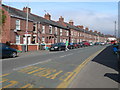
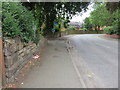
1
Roundabout on Ruabon Road
From Ffordd Victoria
Image: © John Firth
Taken: 15 Apr 2012
0.04 miles
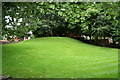
2
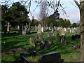
Wrexham Cemetery
Seen from Empress Road.
Image: © Eirian Evans
Taken: 7 Apr 2011
0.07 miles
4
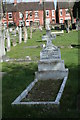
Local Historian
The headstone of well known local historian, A.N.PALMER after whom a research facility room has been named in the Wrexham museum.
Image: © Geoff Evans
Taken: 29 Mar 2012
0.10 miles
5
A curving Fairy Road, and a bench mark
Looking along Fairy Road from opposite its junction with Belmont Road. There is an Ordnance Survey bench mark at this end of the stone wall on the left - Image
Image: © John S Turner
Taken: 21 Jul 2014
0.12 miles
6
Fairy Mount
The ancient Mound in a private garden. It is a large round barrow with a dead hollow oak tree on its summit.
Image: © Geoff Evans
Taken: 10 Aug 2007
0.12 miles
7
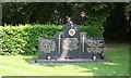
Polish Memorial
This recently commissioned memorial pays tribute to war time members of the Polish Armed Forces of which there are several interred in this Wrexham Cemetery.
Image: © Geoff Evans
Taken: 4 Jun 2010
0.13 miles
8
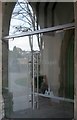
Interior Improvements
The new glass entrance to the chapel at the cemetery gates.
Image: © Geoff Evans
Taken: 30 Oct 2017
0.13 miles
9

Cemetery Chapel, Wrexham Cemetery
Wrexham Cemetery is located on Ruabon Road, Wrexham, and covers an area of 7.2 hectares. The layout of the cemetery was designed by Yeo Strachan. Originally consisting of 10 acres immediately to the rear of the cemetery chapel, the cemetery was designed as a 'garden cemetery' for the 'passive recreation of the people of the Borough'. During Victorian times, walking through cemeteries was a popular pastime. Most of the original layout has been preserved and features much of the original tree planting undertaken by Strachan. The Cemetery Chapel was designed by John Turner and is now a Grade II listed building. Wrexham Cemetery acts as the main burial site for Wrexham, 37,000 burials have taken place at the cemetery since its opening in 1876, with current operation levels being 200 burials per year. (Wrexham County Borough Council website information)
Image: © Eirian Evans
Taken: 7 Apr 2011
0.13 miles
10

Polish War Memorial
A Prominent Position for War Heroes in Wrexham Cemetery
Image: © Geoff Evans
Taken: 4 Jun 2010
0.13 miles