IMAGES TAKEN NEAR TO
Holt Road, WREXHAM, LL13 0UD
Introduction
This page details the photographs taken nearby to Holt Road, LL13 0UD by members of the Geograph project.
The Geograph project started in 2005 with the aim of publishing, organising and preserving representative images for every square kilometre of Great Britain, Ireland and the Isle of Man.

There are currently over 7.5m images from over14,400 individuals and you can help contribute to the project by visiting https://www.geograph.org.uk
Image Map (Loading...)


Getting Data...Please wait
Leaflet Map data © OpenStreetMap
Images are licensed for reuse under creativecommons.org/licenses/by-sa/2.0
Notes
- Clicking on the map will re-center to the selected point.
- The higher the marker number, the further away the image location is from the centre of the postcode.
Image Listing (9 Images Found)
Images are licensed for reuse under creativecommons.org/licenses/by-sa/2.0
Image
Details
Distance
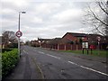
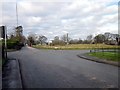
2
Newer housing at Cross lanes
A few houses built at a time and you soon have a housing estate.
Image: © John Haynes
Taken: 17 Oct 2005
0.09 miles
4
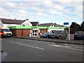
The Co-op at Cross Lanes
The Co-op at the junction of Holt Road and Bedwell Road.
Image: © Jeff Buck
Taken: 20 Jan 2014
0.14 miles
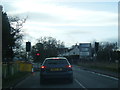
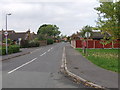
5
The Crossroads at Cross Lanes
Crossroads at Cross Lanes where the A525 (straight ahead) meets Holt Road (on the right) and Kiln Lane (on the left).
Image: © Jeff Buck
Taken: 20 Jan 2014
0.23 miles