IMAGES TAKEN NEAR TO
Vicarage Lane, WREXHAM, LL13 0NH
Introduction
This page details the photographs taken nearby to Vicarage Lane, LL13 0NH by members of the Geograph project.
The Geograph project started in 2005 with the aim of publishing, organising and preserving representative images for every square kilometre of Great Britain, Ireland and the Isle of Man.

There are currently over 7.5m images from over14,400 individuals and you can help contribute to the project by visiting https://www.geograph.org.uk
Image Map (Loading...)


Getting Data...Please wait
Leaflet Map data © OpenStreetMap
Images are licensed for reuse under creativecommons.org/licenses/by-sa/2.0
Notes
- Clicking on the map will re-center to the selected point.
- The higher the marker number, the further away the image location is from the centre of the postcode.
Image Listing (16 Images Found)
Images are licensed for reuse under creativecommons.org/licenses/by-sa/2.0
Image
Details
Distance
1
Penley Polish Hospital
Formerly a wartime hospital, predominantly at war's end for Polish Servicemen.
Image: © Geoff Evans
Taken: 19 Jul 2007
0.04 miles
2
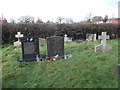
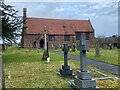
Polish graves at St Mary Magdalene
Towards the end of the 1939-1945 War, two hospitals were established in Penley, for Polish servicemen and ex-servicemen. Many of these servicemen later settled in the area; and more than 120, and their families, are now buried in the churchyard.
Image: © Eirian Evans
Taken: 18 Jan 2018
0.12 miles
3
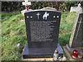
The grave of Witold Kotowski
The gravestone details his family and service history and lists the honours he received.
Image: © Eirian Evans
Taken: 18 Jan 2018
0.12 miles
4
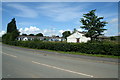
Madras Voluntary Aided School, Penley
Built in 1811 by the 2nd Lord Kenyon and based upon a similar structure in India, the Madras School became the first free school in Wales. It is unique in having a thatched roof. It is beside the A539 on the north-western side of Penley.
Image: © Eirian Evans
Taken: 18 Jan 2018
0.12 miles
5
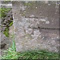
Ordnance Survey Cut Mark
This OS cut mark can be found on the north angle of St Mary Magdalene's Church. It marks a point 65.088m above mean sea level.
Image: © Adrian Dust
Taken: 30 Sep 2016
0.12 miles
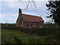
6
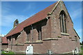
Parish Church of St Mary Magdalene, Penley
Image: © John H Darch
Taken: 16 Feb 2021
0.12 miles
8
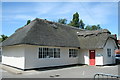
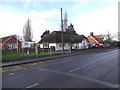
Village School
Very few other thatched schools in this area.
Image: © Geoff Evans
Taken: 19 Jul 2007
0.13 miles
9
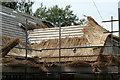
"Your Bald Thatch is Showing."
Already photographed recently, this chance encounter resulted in a conversation with a workman who is in great demand.
Image: © Geoff Evans
Taken: 23 Aug 2007
0.13 miles
10
St Mary Magdalene Church, Penley
This is the third, or possibly fourth, church or chapel on this site. The earliest dates from the 15th century and was constructed of timber, lath and plaster. It was demolished in 1793 and replaced the following year by a plain brick building. The present church was constructed of red Abenbury stone and red clay tiles in 1899-1901.
Image: © Eirian Evans
Taken: 3 Apr 2010
0.13 miles