IMAGES TAKEN NEAR TO
Ludlow Close, WREXHAM, LL13 0JE
Introduction
This page details the photographs taken nearby to Ludlow Close, LL13 0JE by members of the Geograph project.
The Geograph project started in 2005 with the aim of publishing, organising and preserving representative images for every square kilometre of Great Britain, Ireland and the Isle of Man.

There are currently over 7.5m images from over14,400 individuals and you can help contribute to the project by visiting https://www.geograph.org.uk
Image Map
Images are licensed for reuse under creativecommons.org/licenses/by-sa/2.0
Notes
- Clicking on the map will re-center to the selected point.
- The higher the marker number, the further away the image location is from the centre of the postcode.
Image Listing (9 Images Found)
Images are licensed for reuse under creativecommons.org/licenses/by-sa/2.0
Image
Details
Distance
3
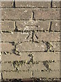
Bench mark on Laurel Cottages garden wall, Station Road
This Ordnance Survey bench mark is on the garden wall of Laurel Cottages, Station Road, Bangor on Dee. See also Image
Image: © John S Turner
Taken: 27 Feb 2011
0.12 miles
4
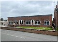
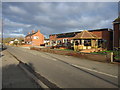
Closed down
The former premises of J.Johnson, Basketware, in Station Road, Bangor.
Image: © John H Darch
Taken: 3 May 2022
0.12 miles
5
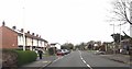
J.Johnson, Basketware, Station Road, Bangor on Dee
Looking across Station Road towards the J.Johnson, Traditional Cane Furniture and Basket Weavers Company, which ceased trading on 3rd February 2019. There is an Ordnance Survey bench mark on the garden wall of the pair of Laurel Cottages further up the road - Image
Image: © John S Turner
Taken: 27 Feb 2011
0.12 miles
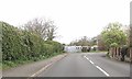
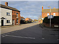
7
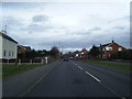
Station Road from Abbot's Way junction
Phone box is point of reference
Image: © John Firth
Taken: 12 Apr 2014
0.20 miles
8
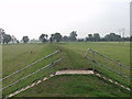
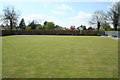
Flood defence banks at Bangor-is-y-coed
Bangor-is-y-coed is on the floodplain of the Afon Dyfrdwy and has a complete ring of flood protection banks which although the town is often cut off in the winter, it is rarely seriously flooded. The steps up and down are to help prevent damage to the grass banks with foot traffic.
Image: © John Haynes
Taken: 15 Oct 2005
0.23 miles
9
Road junction in Bangor-is-y-coed
Looking across the end of Whitchurch Road, with High Street to the left, and Station Road straight ahead - but the station and the railway have long since disappeared.
Image: © John S Turner
Taken: 27 Feb 2011
0.24 miles