IMAGES TAKEN NEAR TO
Lightwood Green, WREXHAM, LL13 0HY
Introduction
This page details the photographs taken nearby to Lightwood Green, LL13 0HY by members of the Geograph project.
The Geograph project started in 2005 with the aim of publishing, organising and preserving representative images for every square kilometre of Great Britain, Ireland and the Isle of Man.

There are currently over 7.5m images from over14,400 individuals and you can help contribute to the project by visiting https://www.geograph.org.uk
Image Map
Images are licensed for reuse under creativecommons.org/licenses/by-sa/2.0
Notes
- Clicking on the map will re-center to the selected point.
- The higher the marker number, the further away the image location is from the centre of the postcode.
Image Listing (5 Images Found)
Images are licensed for reuse under creativecommons.org/licenses/by-sa/2.0
Image
Details
Distance
1
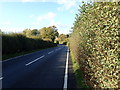
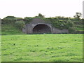
Redundant bridge used as a store
The Ruabon to Penley road crosses the track of the long gone Bangor-is-y-coed to Ellesmere ( Salop ) railway. There is a wood yard in the station site the other side of the road and the space under the bridge is used as a store.
Image: © John Haynes
Taken: 15 Oct 2005
0.10 miles
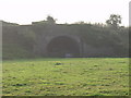
2
Redundant railway bridge
This is a better picture than the one I took last year.
Image: © John Haynes
Taken: 26 Sep 2006
0.14 miles
3
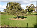
Jacob sheep sheltering from the sun under an apple tree
Image: © Eirian Evans
Taken: 24 Oct 2019
0.17 miles
4
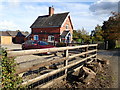
Newal House
Smallholding between Penley and Overton
Image: © Eirian Evans
Taken: 24 Oct 2019
0.20 miles