IMAGES TAKEN NEAR TO
Bangor Road, WREXHAM, LL13 0HL
Introduction
This page details the photographs taken nearby to Bangor Road, LL13 0HL by members of the Geograph project.
The Geograph project started in 2005 with the aim of publishing, organising and preserving representative images for every square kilometre of Great Britain, Ireland and the Isle of Man.

There are currently over 7.5m images from over14,400 individuals and you can help contribute to the project by visiting https://www.geograph.org.uk
Image Map
Images are licensed for reuse under creativecommons.org/licenses/by-sa/2.0
Notes
- Clicking on the map will re-center to the selected point.
- The higher the marker number, the further away the image location is from the centre of the postcode.
Image Listing (5 Images Found)
Images are licensed for reuse under creativecommons.org/licenses/by-sa/2.0
Image
Details
Distance
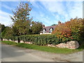
2
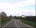
Leaving Overton on B5069
Buildings ahead is Carredg-y-ffranc
Image: © John Firth
Taken: 12 Apr 2014
0.16 miles
3
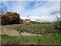
Argoed farmhouse
Built as a farmhouse in the mid-C18, possibly on the site of an earlier building. It is Grade II listed.
Image: © Eirian Evans
Taken: 24 Oct 2019
0.17 miles
4
Argoed Lodge
House on Argoed Lane, North-East of Overton
Image: © Eirian Evans
Taken: 24 Oct 2019
0.17 miles