IMAGES TAKEN NEAR TO
LL13 0FL
Introduction
This page details the photographs taken nearby to LL13 0FL by members of the Geograph project.
The Geograph project started in 2005 with the aim of publishing, organising and preserving representative images for every square kilometre of Great Britain, Ireland and the Isle of Man.

There are currently over 7.5m images from over14,400 individuals and you can help contribute to the project by visiting https://www.geograph.org.uk
Image Map
Images are licensed for reuse under creativecommons.org/licenses/by-sa/2.0
Notes
- Clicking on the map will re-center to the selected point.
- The higher the marker number, the further away the image location is from the centre of the postcode.
Image Listing (2 Images Found)
Images are licensed for reuse under creativecommons.org/licenses/by-sa/2.0
Image
Details
Distance
2
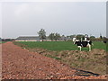
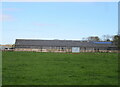
New access road at Cloy Hall Dairy
Cloy Hall Dairy is a large dairy farm consisting mainly modern dairy buildings. Pressure on the small rural roads has led to the installation of a new access road for the cows. The underbed for the road is tile waste from the Ruabon Tile Works at Johnstown, (See Image)
Image: © John Haynes
Taken: 15 Oct 2005
0.22 miles