IMAGES TAKEN NEAR TO
Whitchurch Road, WREXHAM, LL13 0BN
Introduction
This page details the photographs taken nearby to Whitchurch Road, LL13 0BN by members of the Geograph project.
The Geograph project started in 2005 with the aim of publishing, organising and preserving representative images for every square kilometre of Great Britain, Ireland and the Isle of Man.

There are currently over 7.5m images from over14,400 individuals and you can help contribute to the project by visiting https://www.geograph.org.uk
Image Map
Images are licensed for reuse under creativecommons.org/licenses/by-sa/2.0
Notes
- Clicking on the map will re-center to the selected point.
- The higher the marker number, the further away the image location is from the centre of the postcode.
Image Listing (17 Images Found)
Images are licensed for reuse under creativecommons.org/licenses/by-sa/2.0
Image
Details
Distance
1
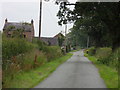
Halghton Hall Lane
Halghton Lodge to the left of the lane.
Image: © J Scott
Taken: 28 Jul 2011
0.01 miles
2
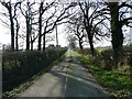
NEW
Rural lane
Nice to walk along on a spring day.
Image: © Jeremy Bolwell
Taken: 9 Mar 2025
0.03 miles
3
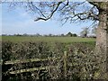
NEW
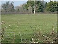
View into a field with some ridge and furrow
Adjacent to another moated site too.
Image: © Jeremy Bolwell
Taken: 9 Mar 2025
0.07 miles
4
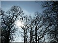
NEW
Rural rookery in March sunshine
Much cawing cacophony from above as nests are built or eggs are fussed over. There are many dropped twigs on the lane surface far below. And droppings. I love a rookery. I listen in to the garrulous, throaty and phleghmy croaks from above and I feel sure they are mocking me and making remarks about my appearance, gait, dress sense or competence. I laugh to myself and plod on, head down as I pass underneath their lofty bower.
Image: © Jeremy Bolwell
Taken: 9 Mar 2025
0.09 miles
5
NEW
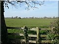
Lumps and bumps - ridge and furrow in a field
There is a lot of this in this area. It is land that was ploughed in antiquity, such as the medieval period, and has not been ploughed with a modern plough and tractor since. So the ridge and furrow survives.
Image: © Jeremy Bolwell
Taken: 9 Mar 2025
0.10 miles
6
NEW
View towards the moated site in a field
Hard to see much as it in on a crown of the hill. But I can see lumps and bumps and the like.
Image: © Jeremy Bolwell
Taken: 9 Mar 2025
0.11 miles
7
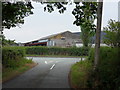
Halghton Hall Lane
Junction with the A525, Pandy Farm buildings opposite.
Image: © J Scott
Taken: 28 Jul 2011
0.12 miles
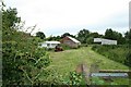
8
NEW
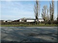
View towards Pandy Farm
Large farm.
Image: © Jeremy Bolwell
Taken: 9 Mar 2025
0.12 miles
9
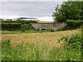
Pandy bridge
The bridge which carries the A525 over the Emral Brook at Pandy.
Image: © Eirian Evans
Taken: 19 Jun 2006
0.17 miles
10
Downsized Farming
A good crop of hay was being harvested by this lady on what appeared to be Quad.
Image: © Geoff Evans
Taken: 28 Jun 2007
0.19 miles