IMAGES TAKEN NEAR TO
Wallington Lane, WREXHAM, LL13 0AL
Introduction
This page details the photographs taken nearby to Wallington Lane, LL13 0AL by members of the Geograph project.
The Geograph project started in 2005 with the aim of publishing, organising and preserving representative images for every square kilometre of Great Britain, Ireland and the Isle of Man.

There are currently over 7.5m images from over14,400 individuals and you can help contribute to the project by visiting https://www.geograph.org.uk
Image Map
Images are licensed for reuse under creativecommons.org/licenses/by-sa/2.0
Notes
- Clicking on the map will re-center to the selected point.
- The higher the marker number, the further away the image location is from the centre of the postcode.
Image Listing (7 Images Found)
Images are licensed for reuse under creativecommons.org/licenses/by-sa/2.0
Image
Details
Distance
1
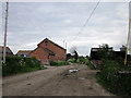
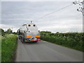
Wallington Farm, Wallington
Wallington Farm on Wallington Lane in Wallington.
Image: © Jeff Buck
Taken: 15 May 2014
0.01 miles
2
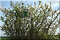
It's a Mystery
The sign appears to be well hidden, but the direction is towards Worthenbury; then again the Blackthorn is a picture.
Image: © Geoff Evans
Taken: 19 Apr 2007
0.07 miles
3

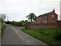
Inaccessible Path, Wallington
No stile and a chained gate making this path inaccessible.
Image: © Jeff Buck
Taken: 15 May 2014
0.08 miles
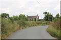
7
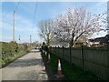
NEW
Blossom tree near the lane in March
I love to see a spring blossom tree.
Image: © Jeremy Bolwell
Taken: 9 Mar 2025
0.24 miles