IMAGES TAKEN NEAR TO
Barracks Lane, WREXHAM, LL12 9TU
Introduction
This page details the photographs taken nearby to Barracks Lane, LL12 9TU by members of the Geograph project.
The Geograph project started in 2005 with the aim of publishing, organising and preserving representative images for every square kilometre of Great Britain, Ireland and the Isle of Man.

There are currently over 7.5m images from over14,400 individuals and you can help contribute to the project by visiting https://www.geograph.org.uk
Image Map (Loading...)


Getting Data...Please wait
Leaflet Map data © OpenStreetMap
Images are licensed for reuse under creativecommons.org/licenses/by-sa/2.0
Notes
- Clicking on the map will re-center to the selected point.
- The higher the marker number, the further away the image location is from the centre of the postcode.
Image Listing (4 Images Found)
Images are licensed for reuse under creativecommons.org/licenses/by-sa/2.0
Image
Details
Distance
1

Field gate and public footpath
Taken directly into the low afternoon sun, the trio of trees on the brow of the hill throw long shadows as far as the gate and stile.
Image: © John S Turner
Taken: 6 Nov 2006
0.03 miles
2
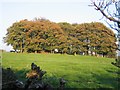
Clump of Trees
This clump of trees, showing their autumn colours, seem to be disguising a prominent mound.
Image: © John S Turner
Taken: 6 Nov 2006
0.07 miles
3

Trees and Field
These trees are the remains of an old boundary that divided this field. (O.S. map 1879)
Image: © John S Turner
Taken: 6 Nov 2006
0.11 miles
4
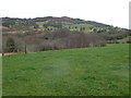
View from Windy Hill northwards
Looking towards Hope Mountain
Image: © Eirian Evans
Taken: 17 Feb 2012
0.23 miles