IMAGES TAKEN NEAR TO
Fagl Lane, WREXHAM, LL12 9HB
Introduction
This page details the photographs taken nearby to Fagl Lane, LL12 9HB by members of the Geograph project.
The Geograph project started in 2005 with the aim of publishing, organising and preserving representative images for every square kilometre of Great Britain, Ireland and the Isle of Man.

There are currently over 7.5m images from over14,400 individuals and you can help contribute to the project by visiting https://www.geograph.org.uk
Image Map
Images are licensed for reuse under creativecommons.org/licenses/by-sa/2.0
Notes
- Clicking on the map will re-center to the selected point.
- The higher the marker number, the further away the image location is from the centre of the postcode.
Image Listing (5 Images Found)
Images are licensed for reuse under creativecommons.org/licenses/by-sa/2.0
Image
Details
Distance
1
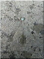
Rivet benchmark on the Afon Alun bridge, Fagl Lane, Hope
Ordnance Survey rivet benchmark on the north parapet of the Fagl Lane bridge over the Afon Alun/River Alyn. The bridge was built in 1933/4 to straighten the road and replaced the earlier Pont y Delyn, which still exists to the south. Levelled at 82.802m above Newlyn Datum, verified 1959. For a wider view see Image
https://www.bench-marks.org.uk/bm195082
Image: © John S Turner
Taken: 22 Aug 2018
0.05 miles
2
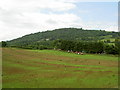
Farmland north of Caergwrle
Hope Mountain is in the background.
Image: © David Quinn
Taken: 6 Jun 2008
0.11 miles
3
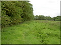
Footpath beside the River Alyn.
A short footpath between Hope railway station and Fagl lane, that also makes up part of a local circular footpath trail.
Image: © David Quinn
Taken: 6 Jun 2008
0.19 miles
4
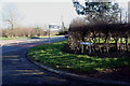
Pentre Lane
Pentre Lane Junction with the dual carriageway looking towards Caergwrle.
Image: © Bob Shires
Taken: 25 Jan 2007
0.21 miles
5
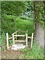
Footbridge over a small Stream.
The footpaths between Waun-y-Llyn country park and Caergwrle and not the most trodden, and resemble a jungle in places. On the other side of the bridge there is a bit of an overgrowth of all sorts of bushes, most with nettles!
Image: © David Quinn
Taken: 6 Jun 2008
0.21 miles