IMAGES TAKEN NEAR TO
Railway Terrace, Fellows Lane, WREXHAM, LL12 9AS
Introduction
This page details the photographs taken nearby to Railway Terrace, Fellows Lane, LL12 9AS by members of the Geograph project.
The Geograph project started in 2005 with the aim of publishing, organising and preserving representative images for every square kilometre of Great Britain, Ireland and the Isle of Man.

There are currently over 7.5m images from over14,400 individuals and you can help contribute to the project by visiting https://www.geograph.org.uk
Image Map
Images are licensed for reuse under creativecommons.org/licenses/by-sa/2.0
Notes
- Clicking on the map will re-center to the selected point.
- The higher the marker number, the further away the image location is from the centre of the postcode.
Image Listing (137 Images Found)
Images are licensed for reuse under creativecommons.org/licenses/by-sa/2.0
Image
Details
Distance
1
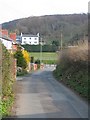
Fellows Lane to the A550
Looking along Fellows Lane, Caergwrle, from where the footpath to the recreation ground joins the lane. Behind the camera the lane goes down to the ancient packhorse bridge, and this end of the lane joins the A550 road from Hope to Caergwrle.
Image: © John S Turner
Taken: 25 Mar 2007
0.03 miles
2
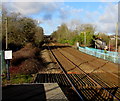
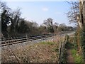
North on the Borderlands Line, Caergwrle, Flintshire
Viewed from Caergwrle station platform 1 looking towards Fellows Lane bridge.
Next station ahead is Hope on the route to Bidston.
Image: © Jaggery
Taken: 29 Jan 2018
0.05 miles
3
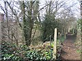
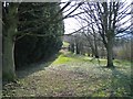
Footpath from Fellows Lane to Hope Recreation Ground
This footpath runs from Fellows Lane, Caergwrle, to Hope recreation ground. The railway between Wrexham and Liverpool is out of sight on the left.
Image: © John S Turner
Taken: 25 Mar 2007
0.06 miles
4
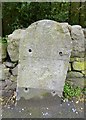
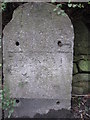
Old Milestone by the A550, Hawarden Road, Hope
Milestone by the A550, in parish of Hope (Flintshire District), Hawarden Road, Bridge End, 50m North of bridge, against wall, opposite "Arfryn". Plate missing.
Inscription once read:-
(Hawarden)
(5¾)
(Wrexham)
(5)
Surveyed
Milestone Society National ID: FLT_WRHW05
Image: © Milestone Society
Taken: Unknown
0.07 miles
5
Old milestone on Hawarden Road
The only thing that identifies this as a milestone is that it is recorded as such on various maps - O.S.1900 shows 'Hawarden 5¼ Wrexham 5'. Clearly it once had an iron plate on the front, and there are also vestiges of illegible characters on the stone.
Image: © John S Turner
Taken: 13 Dec 2009
0.07 miles
6
Footpath to Hope Recreation Ground
This footpath runs from Fellows Lane to Hope recreation ground. The railway line runs from Wrexham to Liverpool.
Image: © John S Turner
Taken: 25 Mar 2007
0.07 miles
7
Footpath from Hope Recreation Ground
This footpath leaves the recreation ground heading for Fellows Lane. The Wrexham to Liverpool railway line runs across the middle of the photo.
Image: © John S Turner
Taken: 25 Mar 2007
0.08 miles
8
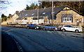
Early Victorian Bridge End Mews, Hawarden Road, Caergwrle, Flintshire
Erected as a school in 1838.
Image: © Jaggery
Taken: 29 Jan 2018
0.08 miles
9
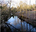
Tranquil side of the River Alyn, Caergwrle, Flintshire
The river on the NW side of Bridge End Bridge contrasts with the white water https://www.geograph.org.uk/photo/5669315 on the SE side of the bridge.
Image: © Jaggery
Taken: 29 Jan 2018
0.11 miles
10
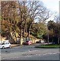
Junction of Rhyddyn Hill and Hawarden Road, Caergwrle, Flintshire
The northwest end of the road named Rhyddyn Hill viewed across the A550 Hawarden Road.
Image: © Jaggery
Taken: 29 Jan 2018
0.11 miles