IMAGES TAKEN NEAR TO
Maple Close, WREXHAM, LL12 8XY
Introduction
This page details the photographs taken nearby to Maple Close, LL12 8XY by members of the Geograph project.
The Geograph project started in 2005 with the aim of publishing, organising and preserving representative images for every square kilometre of Great Britain, Ireland and the Isle of Man.

There are currently over 7.5m images from over14,400 individuals and you can help contribute to the project by visiting https://www.geograph.org.uk
Image Map
Images are licensed for reuse under creativecommons.org/licenses/by-sa/2.0
Notes
- Clicking on the map will re-center to the selected point.
- The higher the marker number, the further away the image location is from the centre of the postcode.
Image Listing (2 Images Found)
Images are licensed for reuse under creativecommons.org/licenses/by-sa/2.0
Image
Details
Distance
1
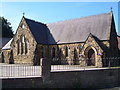
Gresford Methodist Church
This Victorian church is at the junction of Claypit Lane with Chester Road.
Image: © Derek Harper
Taken: 16 Jul 2006
0.16 miles
2
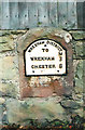
Old Milestone by the B5445 in Gresford
Wrexham plate by the B5445 (was A483), in parish of Gresford (Wrexham County Borough District), Chester Road, opposite Burton Rise, in bus lay-by, set in stone wall.
Inscription reads:-
WREXHAM DISTRICT
TO
..........M
WREXHAM 3
CHESTER 8
Surveyed
Milestone Society National ID: DEN_WRCH03
Image: © Milestone Society
Taken: Unknown
0.23 miles