IMAGES TAKEN NEAR TO
Lon Y Gelli, WREXHAM, LL12 8JZ
Introduction
This page details the photographs taken nearby to Lon Y Gelli, LL12 8JZ by members of the Geograph project.
The Geograph project started in 2005 with the aim of publishing, organising and preserving representative images for every square kilometre of Great Britain, Ireland and the Isle of Man.

There are currently over 7.5m images from over14,400 individuals and you can help contribute to the project by visiting https://www.geograph.org.uk
Image Map
Images are licensed for reuse under creativecommons.org/licenses/by-sa/2.0
Notes
- Clicking on the map will re-center to the selected point.
- The higher the marker number, the further away the image location is from the centre of the postcode.
Image Listing (15 Images Found)
Images are licensed for reuse under creativecommons.org/licenses/by-sa/2.0
Image
Details
Distance
4
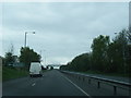
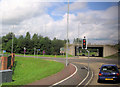
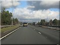
Road junction at A483 junction 6
From southbound A483
Image: © John Firth
Taken: 13 May 2011
0.14 miles
5
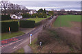
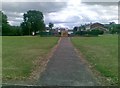
Old Wrexham Road
Old Wrexham Road leads past The Flash towards Gresford. This is the view from the footbridge over the A5156.
Image: © Stephen McKay
Taken: 12 Feb 2019
0.15 miles
7
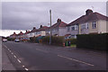
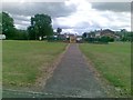
Smithy Lane, Little Acton
A row of semi-detached houses probably dating from the 1930s lines the south side of Smithy Lane; they could be in the suburbs of almost any large town or city in Wales or England. This is the view from close to the junction with Windermere Road.
Image: © Stephen McKay
Taken: 12 Feb 2019
0.17 miles
10
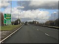
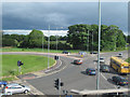
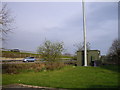
A483 at junction 6 (A5156)
Curiously, the A5156 route number for Nantwich does not feature at all, that for the A534, the main west-east road across Cheshire with which it soon connects being preferred.
Image: © Peter Whatley
Taken: 18 Jan 2011
0.22 miles