IMAGES TAKEN NEAR TO
Greythorne Close, WREXHAM, LL12 8HS
Introduction
This page details the photographs taken nearby to Greythorne Close, LL12 8HS by members of the Geograph project.
The Geograph project started in 2005 with the aim of publishing, organising and preserving representative images for every square kilometre of Great Britain, Ireland and the Isle of Man.

There are currently over 7.5m images from over14,400 individuals and you can help contribute to the project by visiting https://www.geograph.org.uk
Image Map
Images are licensed for reuse under creativecommons.org/licenses/by-sa/2.0
Notes
- Clicking on the map will re-center to the selected point.
- The higher the marker number, the further away the image location is from the centre of the postcode.
Image Listing (96 Images Found)
Images are licensed for reuse under creativecommons.org/licenses/by-sa/2.0
Image
Details
Distance
1
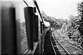
Climbing Gresford Bank, 1960
This was - and to a lesser extent with modern trains still is - a significant climb on the way up to Wrexham, rising at 1 in 82 for 3 ½ miles.
Image: © Alan Murray-Rust
Taken: Unknown
0.07 miles
2
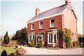
Weston House, Narrow Lane, Gresford 1879-2002
Weston House was built by (or for) Frederick Price of Gresford Mills. It was demolished in 2002 by developers and a modern "Weston House" now stands in its place, similar but not the same.
Image: © Graham Price
Taken: Unknown
0.13 miles
3
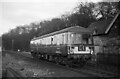
Cravens parcels unit M55998, Gresford ? 1967
As part of the programme of building diesel multiple units as part of the modernisation of British Railways, a small number these single cars, specifically for the carriage of parcels traffic, were ordered. This is one of the three ordered from Cravens of Sheffield in 1958 and which ran in service until 1975.
Image: © Alan Murray-Rust
Taken: 4 Mar 1967
0.15 miles
4
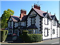
Yew Tree Inn, Gresford
Opposite the church, on the corner of Pant Lane and the High Street.
Image: © Derek Harper
Taken: 16 Jul 2006
0.15 miles
5
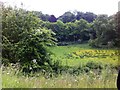
Field and trees seen from an A483 lay-by in Gresford
Image: © Darrin Antrobus
Taken: 10 Jun 2013
0.16 miles
6
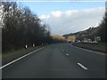
A483 in the Alyn valley
Stylish curves as the dual carriageway descends from Gresford to the Cheshire plain. Lovely engineering.
Image: © Peter Whatley
Taken: 18 Jan 2011
0.16 miles
7
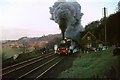
Clun Castle climbing Gresford Bank, 1967
Heading the return working of the 'Zulu' special between London and Birkenhead, run to mark the end of through workings between those two places.
Until a few seconds before this picture, it had been making a steady climb up the gradient, but at this point it seems that the driver suddenly opened the regulator to full port, with almost literally explosive effect. There was a sudden burst of black exhaust, as seen in the view. See also http://www.geograph.org.uk/photo/6441319 .
Image: © Alan Murray-Rust
Taken: 4 Mar 1967
0.16 miles
8
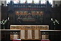
Gresford, All Saints Church: Altar and Last Supper reredos
Image: © Michael Garlick
Taken: 29 Apr 2024
0.17 miles
9
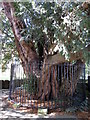
Ancient yew at All Saints', Gresford
Alongside the path from the south east gate. This may be the tree stated to be 1,600 years old. http://www.allsaintsgresford.org.uk/index.php
Image: © John S Turner
Taken: 27 Aug 2009
0.17 miles
10
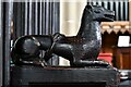
Gresford, All Saints Church: Crouching beasts on the choir stalls
Image: © Michael Garlick
Taken: 29 Apr 2024
0.18 miles