IMAGES TAKEN NEAR TO
Herbert Jennings Avenue, WREXHAM, LL12 7YB
Introduction
This page details the photographs taken nearby to Herbert Jennings Avenue, LL12 7YB by members of the Geograph project.
The Geograph project started in 2005 with the aim of publishing, organising and preserving representative images for every square kilometre of Great Britain, Ireland and the Isle of Man.

There are currently over 7.5m images from over14,400 individuals and you can help contribute to the project by visiting https://www.geograph.org.uk
Image Map (4 Images)


Getting Data...Please wait
Leaflet Map data © OpenStreetMap
Images are licensed for reuse under creativecommons.org/licenses/by-sa/2.0
Notes
- Clicking on the map will re-center to the selected point.
- The higher the marker number, the further away the image location is from the centre of the postcode.
Image Listing (4 Images Found)
Images are licensed for reuse under creativecommons.org/licenses/by-sa/2.0
Image
Details
Distance
1
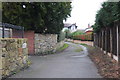
Lane above Acton Park, Wrexham
A lane on the W side of the park, connecting with residential roads by the Primary School.
Image: © Jim Barton
Taken: 25 Dec 2011
0.19 miles
2
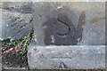
Ordnance Survey Cut Mark
This OS cut mark can be found on the post at the end of a wall which is part of the Acton Park Entrance on Chester Road. It marks a point 100.313m above mean sea level.
Image: © Adrian Dust
Taken: 22 Oct 2021
0.20 miles
3
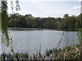
The Lake, Acton Park, Wrecsam
The north part of the lake in the park.
Image: © John Haynes
Taken: 29 Apr 2006
0.24 miles
4
Croes-Eneurys (Eneurys' Cross )
This stone, part of the original stone estate wall (Acton Park) was relocated when the original Chester road was built. It had formed an earlier base of a cross, and was so marked to illustate its Christian origin.
Image: © Geoff Evans
Taken: 27 Feb 2012
0.25 miles