IMAGES TAKEN NEAR TO
Grove Park Road, WREXHAM, LL12 7AA
Introduction
This page details the photographs taken nearby to Grove Park Road, LL12 7AA by members of the Geograph project.
The Geograph project started in 2005 with the aim of publishing, organising and preserving representative images for every square kilometre of Great Britain, Ireland and the Isle of Man.

There are currently over 7.5m images from over14,400 individuals and you can help contribute to the project by visiting https://www.geograph.org.uk
Image Map
Images are licensed for reuse under creativecommons.org/licenses/by-sa/2.0
Notes
- Clicking on the map will re-center to the selected point.
- The higher the marker number, the further away the image location is from the centre of the postcode.
Image Listing (207 Images Found)
Images are licensed for reuse under creativecommons.org/licenses/by-sa/2.0
Image
Details
Distance
1
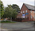
Former Whittingham Riddell office, Grove Park Road, Wrexham
A FOR SALE board is outside the office in September 2016. In October 2017, the Wrexham office of Whittingham Riddell (independent accountancy firm) is at 1 Edison Court, Ellice Way, Wrexham Technology Park.
Image: © Jaggery
Taken: 24 Sep 2016
0.01 miles
2
Champions' House, 9-11 Grove Park Road, Wrexham
In September 2016 Champions' House is the premises of CAIS,
a registered charity and voluntary sector provider of personal support services in Wales.
Image: © Jaggery
Taken: 24 Sep 2016
0.01 miles
3
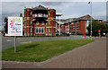
Coleg Cambria - Croeso/Welcome, Wrexham
The sign facing Rhosddu Road is on the southwest approach to the college campus.
Image: © Jaggery
Taken: 24 Sep 2016
0.01 miles
4
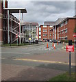
Caution - motorists have priority, Grove Park Road, Wrexham
The sign at the edge of Grove Park Road faces a path on the approach to a college campus.
The caution is also in Welsh.
Image: © Jaggery
Taken: 24 Sep 2016
0.02 miles
5
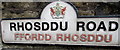
Bilingual name sign, Rhosddu Road/Ffordd Rhosddu, Wrexham
Opposite the King Street junction. The Wrexham crest on the sign includes two red dragons.
Image: © Jaggery
Taken: 24 Sep 2016
0.02 miles
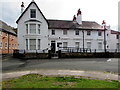
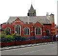
6
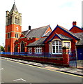
Trinity Presbyterian Church of Wales church and hall, Wrexham
The King Street side of the Edwardian building in a triangular site bounded by King Street to the west and Rhosddu Road to the east. Built in 1908 in the Perpendicular style in red Ruabon brick with stone dressings and slate roofs with terracotta crestings. Grade II listed in 1994.
Image: © Jaggery
Taken: 24 Sep 2016
0.03 miles
7
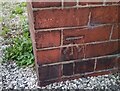
Ordnance Survey Cut Mark
This OS cut mark can be found on the NE face of the Presbyterian Church on Rhos Ddu Road. It marks a point 86.585m above mean sea level.
Image: © Adrian Dust
Taken: 22 Oct 2021
0.03 miles
8
Plato Training, 63 King Street, Wrexham
Viewed in September 2016. At the October 2017 date of this upload to Geograph,
Plato Training's Wrexham office is in Blackwood House, Blackwood Business Park, Ash Road South.
Image: © Jaggery
Taken: 24 Sep 2016
0.03 miles
9
Rhosddu Road side of Trinity Presbyterian Church of Wales church, Wrexham
http://www.geograph.org.uk/photo/5580938 to the King Street side and some details of the Grade II listed Edwardian building.
Image: © Jaggery
Taken: 24 Sep 2016
0.03 miles
10
McLintocks Wrexham office
McLintocks chartered accountants & business advisors located in The Coach House, 25 Rhosddu Road, Wrexham.
Image: © Jaggery
Taken: 24 Sep 2016
0.03 miles