IMAGES TAKEN NEAR TO
Seventh Avenue, WREXHAM, LL12 0SB
Introduction
This page details the photographs taken nearby to Seventh Avenue, LL12 0SB by members of the Geograph project.
The Geograph project started in 2005 with the aim of publishing, organising and preserving representative images for every square kilometre of Great Britain, Ireland and the Isle of Man.

There are currently over 7.5m images from over14,400 individuals and you can help contribute to the project by visiting https://www.geograph.org.uk
Image Map (Loading...)


Getting Data...Please wait
Leaflet Map data © OpenStreetMap
Images are licensed for reuse under creativecommons.org/licenses/by-sa/2.0
Notes
- Clicking on the map will re-center to the selected point.
- The higher the marker number, the further away the image location is from the centre of the postcode.
Image Listing (7 Images Found)
Images are licensed for reuse under creativecommons.org/licenses/by-sa/2.0
Image
Details
Distance
1
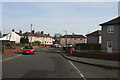
Ffordd Nant-y-Gaer
Ffordd Nant-y-Gaer in the middle of llay Village
Image: © Bob Shires
Taken: 4 Feb 2007
0.14 miles
2
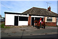
The Llay hunt
A young lady waiting for the barbers shop to open on Nant-Y-Gaer Rd?
Image: © Bob Shires
Taken: 4 Feb 2007
0.20 miles
4
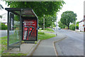
Llay New Road
The bus stop here is served by Arriva's service 33 which runs along Llay New Road to Llay Ring before taking an extraordinarily circuitous route through the housing estate, eventually emerging back on Llay New Road south of here and returning to Wrexham.
Image: © Stephen McKay
Taken: 30 May 2019
0.22 miles
5
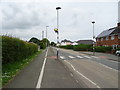
Dual use path beside Llay New Road, Llay
Looking north west.
Image: © JThomas
Taken: 25 May 2019
0.22 miles
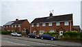
6
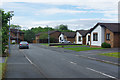
Meadow Rise, Llay
There is quite a variety of house types in Llay including these bungalows on Meadow Rise off Gresford Road.
Image: © Stephen McKay
Taken: 30 May 2019
0.23 miles
7
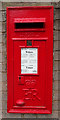
Elizabeth II postbox on Llay New Road, Llay
Postbox No. LL12 333.
See Image] for context.
Image: © JThomas
Taken: 25 May 2019
0.24 miles