IMAGES TAKEN NEAR TO
Chapel Lane, WREXHAM, LL12 0PA
Introduction
This page details the photographs taken nearby to Chapel Lane, LL12 0PA by members of the Geograph project.
The Geograph project started in 2005 with the aim of publishing, organising and preserving representative images for every square kilometre of Great Britain, Ireland and the Isle of Man.

There are currently over 7.5m images from over14,400 individuals and you can help contribute to the project by visiting https://www.geograph.org.uk
Image Map (Loading...)


Getting Data...Please wait
Leaflet Map data © OpenStreetMap
Images are licensed for reuse under creativecommons.org/licenses/by-sa/2.0
Notes
- Clicking on the map will re-center to the selected point.
- The higher the marker number, the further away the image location is from the centre of the postcode.
Image Listing (4 Images Found)
Images are licensed for reuse under creativecommons.org/licenses/by-sa/2.0
Image
Details
Distance
1
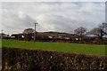
Hope Mountain
Hope Mountain with the edge of the Llay Industrial Estate on the left. Viewed from Chapel Lane.
Image: © Bob Shires
Taken: 21 Jan 2007
0.15 miles
2
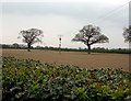
Bare trees and fields
An early spring outlook with bare trees and the field freshly prepared for this year's crop.
Image: © Bob Shires
Taken: 14 Apr 2009
0.16 miles
3
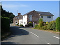
Cottages on Chapel Lane, near Llay
Taken from the junction of Higher Lane, Dark Lane and Chapel Lane, looking towards Llay.
Image: © Derek Harper
Taken: 16 Jul 2006
0.17 miles
4
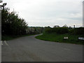
Dark Lane
Looking downhill down Dark Lane from where it becomes Higher Lane
Image: © Bob Shires
Taken: 14 Apr 2009
0.21 miles