IMAGES TAKEN NEAR TO
Bryn Place, WREXHAM, LL12 0LT
Introduction
This page details the photographs taken nearby to Bryn Place, LL12 0LT by members of the Geograph project.
The Geograph project started in 2005 with the aim of publishing, organising and preserving representative images for every square kilometre of Great Britain, Ireland and the Isle of Man.

There are currently over 7.5m images from over14,400 individuals and you can help contribute to the project by visiting https://www.geograph.org.uk
Image Map
Images are licensed for reuse under creativecommons.org/licenses/by-sa/2.0
Notes
- Clicking on the map will re-center to the selected point.
- The higher the marker number, the further away the image location is from the centre of the postcode.
Image Listing (4 Images Found)
Images are licensed for reuse under creativecommons.org/licenses/by-sa/2.0
Image
Details
Distance
1
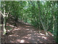
Path from Singret to Llay
The path through Nant-y-Gaer Wood, from just above the footbridge near Singret.
Image: © Derek Harper
Taken: 16 Jul 2006
0.19 miles
2
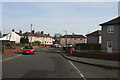
Ffordd Nant-y-Gaer
Ffordd Nant-y-Gaer in the middle of llay Village
Image: © Bob Shires
Taken: 4 Feb 2007
0.20 miles
3
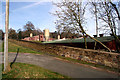
Chicken Farm
A chicken farm beside the B5373
Image: © Bob Shires
Taken: 4 Feb 2007
0.20 miles
4
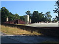
Poultry farm, Gresford Road
Close to the River Alyn between Gresford and Llay, seen from the junction with Pentre Lane.
Image: © Derek Harper
Taken: 16 Jul 2006
0.22 miles