IMAGES TAKEN NEAR TO
Gamford Lane, WREXHAM, LL12 0EW
Introduction
This page details the photographs taken nearby to Gamford Lane, LL12 0EW by members of the Geograph project.
The Geograph project started in 2005 with the aim of publishing, organising and preserving representative images for every square kilometre of Great Britain, Ireland and the Isle of Man.

There are currently over 7.5m images from over14,400 individuals and you can help contribute to the project by visiting https://www.geograph.org.uk
Image Map (Loading...)


Getting Data...Please wait
Leaflet Map data © OpenStreetMap
Images are licensed for reuse under creativecommons.org/licenses/by-sa/2.0
Notes
- Clicking on the map will re-center to the selected point.
- The higher the marker number, the further away the image location is from the centre of the postcode.
Image Listing (4 Images Found)
Images are licensed for reuse under creativecommons.org/licenses/by-sa/2.0
Image
Details
Distance
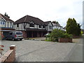
1

Start of footpath, Lavister
Footpath leads across former golf course from unmetalled road near Darland Hall to entrance between Lavister and Pulford.
Image: © Dave Dunford
Taken: 14 Sep 2014
0.22 miles
3
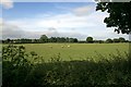
Field of sheep near Rossett
Sheep in a field seen from the B5102 (Rossett Road).
Image: © Jeff Buck
Taken: 1 Jun 2011
0.24 miles
4
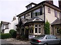
Nags Head Darland
Nice Pub just in Wales but sporting England flags inside for the World Cup.
Image: © Michael Graham
Taken: 16 Jun 2006
0.25 miles