IMAGES TAKEN NEAR TO
Chester Road, WREXHAM, LL12 0DW
Introduction
This page details the photographs taken nearby to Chester Road, LL12 0DW by members of the Geograph project.
The Geograph project started in 2005 with the aim of publishing, organising and preserving representative images for every square kilometre of Great Britain, Ireland and the Isle of Man.

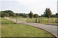
There are currently over 7.5m images from over14,400 individuals and you can help contribute to the project by visiting https://www.geograph.org.uk
Image Map (Loading...)


Getting Data...Please wait
Leaflet Map data © OpenStreetMap
Images are licensed for reuse under creativecommons.org/licenses/by-sa/2.0
Notes
- Clicking on the map will re-center to the selected point.
- The higher the marker number, the further away the image location is from the centre of the postcode.
Image Listing (44 Images Found)
Images are licensed for reuse under creativecommons.org/licenses/by-sa/2.0
Image
Details
Distance
1

Border Crossing
Looking towards Wales (and the village of Lavister) from the Welsh / English border over Pulford Brook.
Image: © Ian Paterson
Taken: 15 Jun 2009
0.02 miles
2

Nag's Head, Lavister
On the B5445 between Wrexham and Chester.
Image: © Eirian Evans
Taken: 17 Sep 2008
0.03 miles

4

Sign for the Nags Head, Lavister
See Image] for context.
Image: © JThomas
Taken: 25 May 2019
0.05 miles
5
Entrance to former golf course between Pulford and Lavister
Formerly the entrance to Darland Golf Club, a nine-hole course that was constructed in 1999 and was up for sale as of 2013. It seems to have closed in July 2014.
Image: © Dave Dunford
Taken: 14 Sep 2014
0.08 miles
6
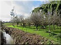
The gardens of the Grosvenor Hotel and the Pulford Brook
The neatly manicured gardens of the hotel and spa are bounded by the Pulford Brook, the England-Wales border.
Image: © Mike Parker
Taken: 17 Feb 2022
0.15 miles
7
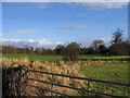
View across Lavister Brook and Darland Golf Course
The view across Darland Golf Course from a field gate alongside Wrexham Road. The line of rough grass across the photo marks the line of Lavister Brook.
Image: © John S Turner
Taken: 3 Dec 2007
0.16 miles
8
Home Rule
Evidence of Welsh nationalist feeling by the England/Wales border on the edge of Pulford.
Image: © Dave Dunford
Taken: 14 Sep 2014
0.16 miles
9
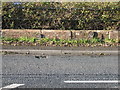
Stop valve markers by Pulford Bridge
These old 'S.V' markers are on the west side of the road on the Welsh side of Pulford Bridge. They show the distance to the valve '5 FEET' and the initials 'W&E.D W Co', which refer to the Wrexham and East Denbighshire Water Company. The earliest reference I have found to this company is in Hansard in 1921.
Image: © John S Turner
Taken: 3 Dec 2007
0.16 miles
10
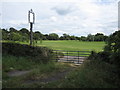
Field gate and Darland Golf Course
A view from Wrexham Road, close to Pulford Bridge, across Darland Golf Course. Lavister Brook flows under the concrete bridge just inside the gate and joins Pulford Brook at Pulford Bridge a short distance to the left. The straight line of mature trees over to the left is Pulford Approach, formerly a carriage drive to Eaton Hall for the Westminster estate.
Image: © John S Turner
Taken: 27 Aug 2009
0.17 miles