IMAGES TAKEN NEAR TO
Cherryfield, WREXHAM, LL11 6JF
Introduction
This page details the photographs taken nearby to Cherryfield, LL11 6JF by members of the Geograph project.
The Geograph project started in 2005 with the aim of publishing, organising and preserving representative images for every square kilometre of Great Britain, Ireland and the Isle of Man.

There are currently over 7.5m images from over14,400 individuals and you can help contribute to the project by visiting https://www.geograph.org.uk
Image Map
Images are licensed for reuse under creativecommons.org/licenses/by-sa/2.0
Notes
- Clicking on the map will re-center to the selected point.
- The higher the marker number, the further away the image location is from the centre of the postcode.
Image Listing (5 Images Found)
Images are licensed for reuse under creativecommons.org/licenses/by-sa/2.0
Image
Details
Distance
1
Flight of steps at Moss Valley Country Park
This flight of steps leads down to the lower lake, at Moss Valley Country Park, from the former trackbed of the Wrexham Mold and Connah's Quay Railway. See also the same steps coming up Image http://www.wrexham.gov.uk/english/leisure_tourism/moss_valley.htm
Image: © John S Turner
Taken: 7 Nov 2008
0.17 miles
2
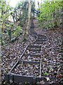
Flight of steps at Moss Valley Country Park
This flight of steps leads up from the path around the bottom lake to the former trackbed of the Wrexham Mold and Connah's Quay Railway. http://www.wrexham.gov.uk/english/leisure_tourism/moss_valley.htm
Image: © John S Turner
Taken: 7 Nov 2008
0.19 miles
3
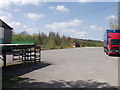
Gatewen Colliery Yard, New Broughton
The old colliery yard is now used as a vehicle training centre. http://www.gatewen.com/
Image: © John Haynes
Taken: 29 Apr 2006
0.22 miles
4
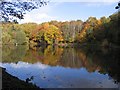
Autumn tints at Moss Valley Country Park
A view across the lower lake at Moss Valley Country Park. http://www.wrexham.gov.uk/english/leisure_tourism/moss_valley.htm
Image: © John S Turner
Taken: 7 Nov 2008
0.23 miles
5
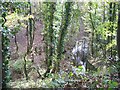
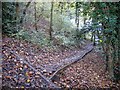
Stream and woodland at Moss Valley Country Park
Looking down on the outflow stream from the lower lake at the Moss Valley Country Park. The wooden gate on the left is for the footpath that continues down the valley. The photo is taken from the embankment of the former Wrexham Mold and Connah's Quay Railway. http://www.wrexham.gov.uk/english/leisure_tourism/moss_valley.htm
Image: © John S Turner
Taken: 7 Nov 2008
0.24 miles